
Geographic Region: USA-ILLINOIS
Feature: IL., MO. & MS. RIVERS
|
Geographic Region: USA-ILLINOIS Feature: IL., MO. & MS. RIVERS |
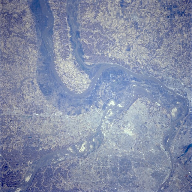 |
| STS062-081-002 Post 1993 Flood, St. Louis Area, Missouri U.S.A. March 1994 This view shows the floodplains and the confluence of the Missouri, Mississippi, and Illinois Rivers, just north of St. Louis. The Illinois River, from top center, joins the Mississippi River midway between the center and upper center of the image. The Missouri River, entering the view near the bottom left of the image, joins the Mississippi River north of St. Louis near the right center. This photo was taken in March, 1994, less than a year after the great floods of the spring and summer of 1993. The flooding that occurred in this region was one of the worst experienced during the 20th century. The flooding deposited silts and sands in the floodplains, seen here as the gray-tan colored regions around the rivers. |
| Images: | All Available Images Low-Resolution 166k |
|
| Mission: | STS062 |
|
| Roll - Frame: | 81 - 2 |
|
| Geographical Name: | USA-ILLINOIS |
|
| Features: | IL., MO. & MS. RIVERS |
|
| Center Lat x Lon: | 39.0N x 90.5W |
|
| Film Exposure: | N | N=Normal exposure, U=Under exposed, O=Over exposed, F=out of Focus |
| Percentage of Cloud Cover-CLDP: | 0 |
|
| Camera:: | HB |
|
| Camera Tilt: | 16 | LO=Low Oblique, HO=High Oblique, NV=Near Vertical |
| Camera Focal Length: | 250 |
|
| Nadir to Photo Center Direction: | E | The direction from the nadir to the center point, N=North, S=South, E=East, W=West |
| Stereo?: | Y | Y=Yes there is an adjacent picture of the same area, N=No there isn't |
| Orbit Number: | 3 |
|
| Date: | 19940304 | YYYYMMDD |
| Time: | 170639 | GMT HHMMSS |
| Nadir Lat: | 38.7N |
Latitude of suborbital point of spacecraft |
| Nadir Lon: | 91.2W |
Longitude of suborbital point of spacecraft |
| Sun Azimuth: | 156 | Clockwise angle in degrees from north to the sun measured at the nadir point |
| Space Craft Altitude: | 161 | nautical miles |
| Sun Elevation: | 42 | Angle in degrees between the horizon and the sun, measured at the nadir point |
| Land Views: | VALLEY |
|
| Water Views: | RIVER |
|
| Atmosphere Views: | |
|
| Man Made Views: | URBAN AREA |
|
| City Views: | ST. LOUIS |
|
Associated Photos in Sequence:  Photo #: STS040-72-23 Photo #: STS040-72-23Description: ST. LOUIS, MISSOURI AREA-1991; LAND PATTERNS BEFORE 1993 SUMMER FLOOD Sequence ID: 4A  Photo #: STS062-81-2 ** Currently displayed photo ** Photo #: STS062-81-2 ** Currently displayed photo ** Description: ST. LOUIS, MISSOURI AREA-1994; LAND PATTERNS AFTER 1993 SUMMER FLOOD Sequence ID: 4B | ||
| NASA Home Page |
JSC Home Page |
JSC Digital Image Collection |
Earth Science & Remote Sensing |
|
This service is provided by the International Space Station program and the JSC Earth Science & Remote Sensing Unit, ARES Division, Exploration Integration Science Directorate.

|