
Geographic Region: USA-TEXAS
Feature: ABILENE, AGRICULTURE
|
Geographic Region: USA-TEXAS Feature: ABILENE, AGRICULTURE |
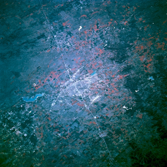 |
| STS062-076-116 Abilene, Texas, U.S.A. March 1994 Abilene, surrounded by agricultural and pasture lands (shown in red) and bordered on the north by Interstate Highway 20, lies on a flat plain in the eastern Permian Basin. Viewing clockwise from U.S. Highway 83, which leads northwest from the city, are Fort Phantom Hill Lake, Abilene Municipal Airport southeast of the city, and Dyess Air Force Base to the southwest. South of Abilene, dark Callahan Divide, a high, flat-topped ridge of limestone, extends in an east-west orientation paralleling Interstate Highway 20. |
| Images: | All Available Images Low-Resolution 389k |
|
| Mission: | STS062 |
|
| Roll - Frame: | 76 - 116 |
|
| Geographical Name: | USA-TEXAS |
|
| Features: | ABILENE, AGRICULTURE |
|
| Center Lat x Lon: | 32.5N x 100W |
|
| Film Exposure: | N | N=Normal exposure, U=Under exposed, O=Over exposed, F=out of Focus |
| Percentage of Cloud Cover-CLDP: | 0 |
|
| Camera:: | HB |
|
| Camera Tilt: | 43 | LO=Low Oblique, HO=High Oblique, NV=Near Vertical |
| Camera Focal Length: | 250 |
|
| Nadir to Photo Center Direction: | E | The direction from the nadir to the center point, N=North, S=South, E=East, W=West |
| Stereo?: | N | Y=Yes there is an adjacent picture of the same area, N=No there isn't |
| Orbit Number: | 193 |
|
| Date: | 19940316 | YYYYMMDD |
| Time: | 145911 | GMT HHMMSS |
| Nadir Lat: | 32.7N |
Latitude of suborbital point of spacecraft |
| Nadir Lon: | 101.7W |
Longitude of suborbital point of spacecraft |
| Sun Azimuth: | 109 | Clockwise angle in degrees from north to the sun measured at the nadir point |
| Space Craft Altitude: | 109 | nautical miles |
| Sun Elevation: | 25 | Angle in degrees between the horizon and the sun, measured at the nadir point |
| Land Views: | PLAIN, RANGE |
|
| Water Views: | RESERVOIR |
|
| Atmosphere Views: | |
|
| Man Made Views: | HIGHWAY, URBAN AREA, AIRPORT, AGRICULTURE |
|
| City Views: | ABILENE |
|
Photo is not associated with any sequences | ||
| NASA Home Page |
JSC Home Page |
JSC Digital Image Collection |
Earth Science & Remote Sensing |
|
This service is provided by the International Space Station program and the JSC Earth Science & Remote Sensing Unit, ARES Division, Exploration Integration Science Directorate.

|