Geographic Region: USA-FLORIDA
Feature: UPPER PEN., LAKES,CITIES
|
Geographic Region: USA-FLORIDA Feature: UPPER PEN., LAKES,CITIES |
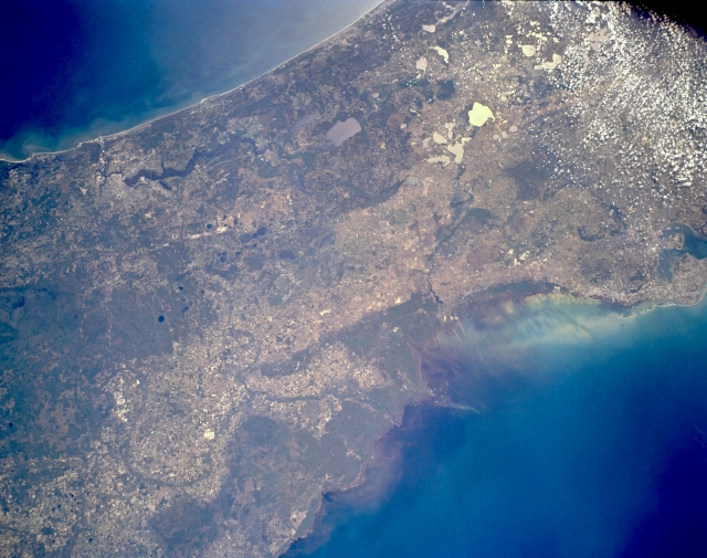 |
| STS062-153-146 Northeast Florida, U.S.A. March 1994 Northeastern Florida is a land bridge between the Atlantic Ocean (top) and the Gulf of Mexico (bottom right). In addition to three of Florida's popular cities--Jacksonville (upper left), Clearwater, and Tampa (barely discernible along middle right)--several natural features are apparent--north-flowing Saint Johns River south of Jacksonville; numerous oval karst lakes with sunglint, which helps identify scattered lakes throughout north-central Florida; large Okefenokee Swamp of southeast Georgia with a small section in Florida northwest of Jacksonville; and the Gulf of Mexico surrounding the delta of the winding Suwanne River (near bottom center). Because this is an area of very low relief (relatively flat topography near sea level), most of the densely vegetated areas are swamplands. Scattered cumulus clouds are apparent in the upper right corner. |
| Images: | All Available Images Low-Resolution 285k |
|
| Mission: | STS062 |
|
| Roll - Frame: | 153 - 146 |
|
| Geographical Name: | USA-FLORIDA |
|
| Features: | UPPER PEN., LAKES,CITIES |
|
| Center Lat x Lon: | 29.5N x 82W |
|
| Film Exposure: | N | N=Normal exposure, U=Under exposed, O=Over exposed, F=out of Focus |
| Percentage of Cloud Cover-CLDP: | 5 |
|
| Camera:: | LH |
|
| Camera Tilt: | 42 | LO=Low Oblique, HO=High Oblique, NV=Near Vertical |
| Camera Focal Length: | 90 |
|
| Nadir to Photo Center Direction: | E | The direction from the nadir to the center point, N=North, S=South, E=East, W=West |
| Stereo?: | Y | Y=Yes there is an adjacent picture of the same area, N=No there isn't |
| Orbit Number: | 161 |
|
| Date: | 19940314 | YYYYMMDD |
| Time: | 151731 | GMT HHMMSS |
| Nadir Lat: | 30.1N |
Latitude of suborbital point of spacecraft |
| Nadir Lon: | 84W |
Longitude of suborbital point of spacecraft |
| Sun Azimuth: | 126 | Clockwise angle in degrees from north to the sun measured at the nadir point |
| Space Craft Altitude: | 140 | nautical miles |
| Sun Elevation: | 42 | Angle in degrees between the horizon and the sun, measured at the nadir point |
| Land Views: | COAST, PLAIN |
|
| Water Views: | RIVER, LAKE, SWAMP |
|
| Atmosphere Views: | |
|
| Man Made Views: | |
|
| City Views: | |
|
Photo is not associated with any sequences | ||
| NASA Home Page |
JSC Home Page |
JSC Digital Image Collection |
Earth Science & Remote Sensing |
|
This service is provided by the International Space Station program and the JSC Earth Science & Remote Sensing Unit, ARES Division, Exploration Integration Science Directorate.

|