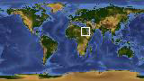
 Photo #: STS062-110-AA Date: Mar. 1994
Geographic Region: SAUDI ARABIA
Feature: AN NAFUD, PIVOT AGRICULTURE
|
Photo #: STS062-110-AA Date: Mar. 1994 Geographic Region: SAUDI ARABIA Feature: AN NAFUD, PIVOT AGRICULTURE |
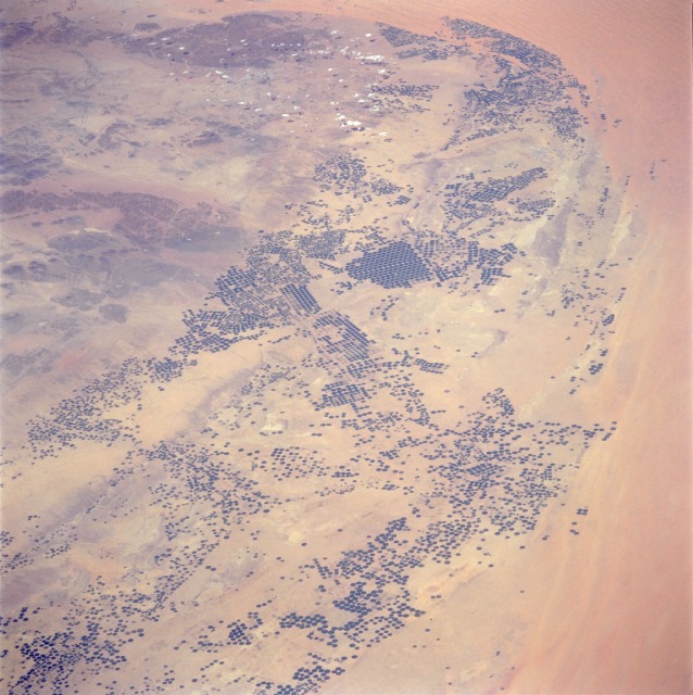 |
| STS062-110-0AA Irrigated Agriculture, Saudi Arabia March 1994 During the last two decades, the Saudi Arabia Government has invested in making the country self-sufficient in food production. As a result, widespread drilling for water increased, producing crop surpluses. This low-oblique, panoramic photograph shows a large area northwest of the capital of Riyadh, where the Saudis have converted nonvegetated desert land into thousands of circular, center-pivot-irrigated, cultivated fields. These irrigated fields vary in size from hundreds of yards (hundreds of meters) to more than a mile (2 kilometers) in diameter. This photograph shows a gradual arc that extends in a swath from south-southwest of Riyadh to the An Nafud (red desert) in northwest Saudi Arabia where center-pivot irrigation has transformed the desert into productive farmland. This drilling activity has been extremely costly, and the underground water supply (fossil water) is proving to be a one-time-only, nonrenewable resource. In the short term, the country has benefited by increasing its food production for internal consumption; however, because of a finite subsurface water supply, some scientific forecasters predict that in the near future the Saudi Arabian desert agriculture may revert to the original, nonvegetated desert environment. |
| Images: | All Available Images Low-Resolution 129k |
|
| Mission: | STS062 |
|
| Roll - Frame: | 110 - AA |
|
| Geographical Name: | SAUDI ARABIA |
|
| Features: | AN NAFUD, PIVOT AGRICULTURE |
|
| Center Lat x Lon: | 26.5N x 42.5E |
|
| Film Exposure: | N | N=Normal exposure, U=Under exposed, O=Over exposed, F=out of Focus |
| Percentage of Cloud Cover-CLDP: | 5 |
|
| Camera:: | HB |
|
| Camera Tilt: | LO=Low Oblique, HO=High Oblique, NV=Near Vertical |
|
| Camera Focal Length: | 250 |
|
| Nadir to Photo Center Direction: | The direction from the nadir to the center point, N=North, S=South, E=East, W=West |
|
| Stereo?: | Y | Y=Yes there is an adjacent picture of the same area, N=No there isn't |
| Orbit Number: | |
|
| Date: | 199403__ | YYYYMMDD |
| Time: | GMT HHMMSS |
|
| Nadir Lat: | N |
Latitude of suborbital point of spacecraft |
| Nadir Lon: | E |
Longitude of suborbital point of spacecraft |
| Sun Azimuth: | Clockwise angle in degrees from north to the sun measured at the nadir point |
|
| Space Craft Altitude: | nautical miles |
|
| Sun Elevation: | Angle in degrees between the horizon and the sun, measured at the nadir point |
|
| Land Views: | DESERT, HILL, DUNE |
|
| Water Views: | |
|
| Atmosphere Views: | |
|
| Man Made Views: | PIVOT IRRIGATION, AGRICULTURE |
|
| City Views: | |
|
Associated Photos in Sequence:  Photo #: STS032-96-32 Photo #: STS032-96-32Description: SAUDI ARABIA, NAFUD-1990; CHANGING DESERT PIVOT IRRIGATION PATTERNS Sequence ID: 8A  Photo #: STS060-97-38 Photo #: STS060-97-38Description: SAUDI ARABIA, NAFUD-1/94; CHANGING DESERT PIVOT IRRIGATION PATTERNS Sequence ID: 8B  Photo #: STS062-110-AA ** Currently displayed photo ** Photo #: STS062-110-AA ** Currently displayed photo ** Description: SAUDI ARABIA, NAFUD-3/94; CHANGING DESERT PIVOT IRRIGATION PATTERNS Sequence ID: 8C | ||
| NASA Home Page |
JSC Home Page |
JSC Digital Image Collection |
Earth Science & Remote Sensing |

This service is provided by the International Space Station program and the JSC Earth Science & Remote Sensing Unit, ARES Division, Exploration Integration Science Directorate.

|