
Geographic Region: USA-VIRGINIA
Feature: JAMES R., NORFOLK, BAY
|
Geographic Region: USA-VIRGINIA Feature: JAMES R., NORFOLK, BAY |
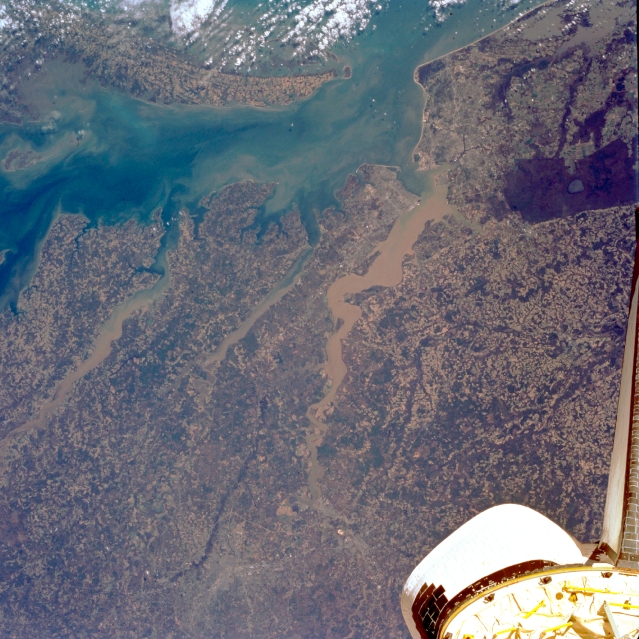 |
| STS062-105-184 Chesapeake Bay, Rappahannock and James Rivers, Virginia March 1994 Three rivers empty into Chesapeake Bay in this east-southeast-looking view. Chesapeake Bay, a 200 mile (320 km) long drowned river mouth is visible at upper left and center. The southern end of the Delmarva Peninsula is discernible through scattered clouds. The forested Dismal Swamp appears as a dark area on the upper right side of the image. The Rappanhannock (left-center) is a 212 mile (340 km) long river that originates in the Blue Ridge Mountains of northern Virginia. The Rappanhannock is navigable to Fredricksburg, Virginia. To the south of the Rappanhannock is the smaller York River, which is nearly 40 miles (64 km) long. The sediment laden 340 mile (547 km) long James River flows into the southern portion of Chesapeake Bay. Formed in west central Virginia, the James River flows from the scenic gorges in the Blue Ridge Mountains and the Piedmont to the Chesapeake Bay. The James River is navigable for large ships to near the city of Petersburg, Virginia, a distance of 100 miles ( 160 km ). The tail of the Space Shuttle is also visible in the image. |
| Images: | All Available Images Low-Resolution 377k |
|
| Mission: | STS062 |
|
| Roll - Frame: | 105 - 184 |
|
| Geographical Name: | USA-VIRGINIA |
|
| Features: | JAMES R., NORFOLK, BAY |
|
| Center Lat x Lon: | 37.5N x 76.5W |
|
| Film Exposure: | N | N=Normal exposure, U=Under exposed, O=Over exposed, F=out of Focus |
| Percentage of Cloud Cover-CLDP: | 5 |
|
| Camera:: | HB |
|
| Camera Tilt: | 24 | LO=Low Oblique, HO=High Oblique, NV=Near Vertical |
| Camera Focal Length: | 100 |
|
| Nadir to Photo Center Direction: | NE | The direction from the nadir to the center point, N=North, S=South, E=East, W=West |
| Stereo?: | Y | Y=Yes there is an adjacent picture of the same area, N=No there isn't |
| Orbit Number: | 113 |
|
| Date: | 19940311 | YYYYMMDD |
| Time: | 145806 | GMT HHMMSS |
| Nadir Lat: | 36.8N |
Latitude of suborbital point of spacecraft |
| Nadir Lon: | 77.5W |
Longitude of suborbital point of spacecraft |
| Sun Azimuth: | 133 | Clockwise angle in degrees from north to the sun measured at the nadir point |
| Space Craft Altitude: | 161 | nautical miles |
| Sun Elevation: | 38 | Angle in degrees between the horizon and the sun, measured at the nadir point |
| Land Views: | PLAIN, FOREST |
|
| Water Views: | RIVER, SEDIMENT, BAY |
|
| Atmosphere Views: | |
|
| Man Made Views: | |
|
| City Views: | |
|
Photo is not associated with any sequences | ||
| NASA Home Page |
JSC Home Page |
JSC Digital Image Collection |
Earth Science & Remote Sensing |
|
This service is provided by the International Space Station program and the JSC Earth Science & Remote Sensing Unit, ARES Division, Exploration Integration Science Directorate.

|