Geographic Region: SPAIN
Feature: ALMERIA PLAINS
|
Geographic Region: SPAIN Feature: ALMERIA PLAINS |
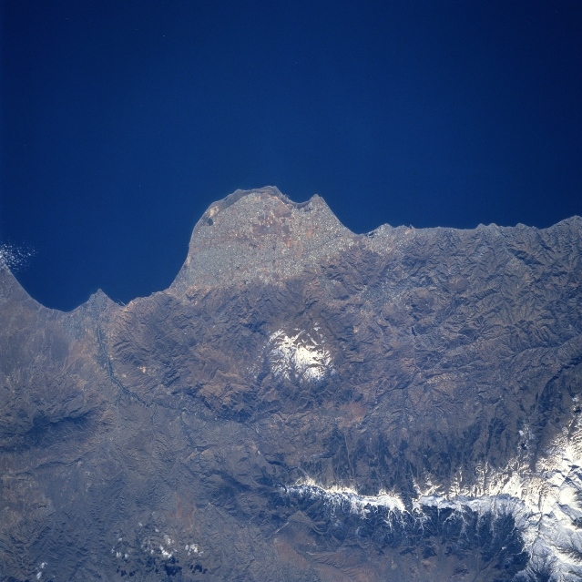 |
| STS060-090-065 Almeria Peninsula, Spain February, 1994 The Plains of Almeria (center of image) is a unique looking landform along the southeast coast of Spain. In spite of a desert-like climate, recent economic development along this flat surfaced, rounded peninsula that protrudes into the Mediterranean Sea has stimulated a growing tourist industry along this coast. The port city of Almeria (estimated population over 160000) is located between the eastern edge of the Plains of Almeria and the Almeria River delta (left of center). The two white areas on the image are two mountain ranges: the Sierra de Gador (smaller range near the center of the image) and the more massive and higher Sierra Nevada range. Several tributary streams (ephemeral) of the Almeria River are discernible in the lower left quadrant of the image. |
| Images: | All Available Images Low-Resolution 324k |
|
| Mission: | STS060 |
|
| Roll - Frame: | 90 - 65 |
|
| Geographical Name: | SPAIN |
|
| Features: | ALMERIA PLAINS |
|
| Center Lat x Lon: | 37.0N x 3W |
|
| Film Exposure: | N | N=Normal exposure, U=Under exposed, O=Over exposed, F=out of Focus |
| Percentage of Cloud Cover-CLDP: | 0 |
|
| Camera:: | HB |
|
| Camera Tilt: | 27 | LO=Low Oblique, HO=High Oblique, NV=Near Vertical |
| Camera Focal Length: | 250 |
|
| Nadir to Photo Center Direction: | E | The direction from the nadir to the center point, N=North, S=South, E=East, W=West |
| Stereo?: | N | Y=Yes there is an adjacent picture of the same area, N=No there isn't |
| Orbit Number: | 127 |
|
| Date: | 19940211 | YYYYMMDD |
| Time: | 125646 | GMT HHMMSS |
| Nadir Lat: | 37.0N |
Latitude of suborbital point of spacecraft |
| Nadir Lon: | 4.6W |
Longitude of suborbital point of spacecraft |
| Sun Azimuth: | 187 | Clockwise angle in degrees from north to the sun measured at the nadir point |
| Space Craft Altitude: | 191 | nautical miles |
| Sun Elevation: | 39 | Angle in degrees between the horizon and the sun, measured at the nadir point |
| Land Views: | PLAIN, MOUNTAIN |
|
| Water Views: | SEA |
|
| Atmosphere Views: | |
|
| Man Made Views: | |
|
| City Views: | |
|
Photo is not associated with any sequences | ||
| NASA Home Page |
JSC Home Page |
JSC Digital Image Collection |
Earth Science & Remote Sensing |
|
This service is provided by the International Space Station program and the JSC Earth Science & Remote Sensing Unit, ARES Division, Exploration Integration Science Directorate.

|