Geographic Region: CHILE
Feature: CHONOS ARCHIPELAGO, MTS.
|
Geographic Region: CHILE Feature: CHONOS ARCHIPELAGO, MTS. |
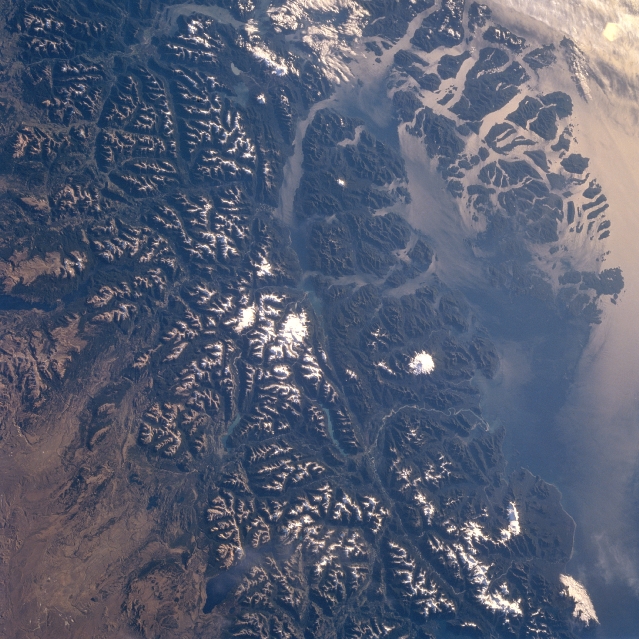 |
| STS060-085-0AH Andes Mountains, Chonos Archipelago, Chile February 1994 The rugged snow-capped Andes Mountains and the islands of the Chonos Archipelago can be seen in this southwest-looking view. Glaciers that formed during an ice age 12000 to 15000 years ago carved the u-shaped valleys in the region. The glacial process shaped the coast shown in this image, into fjords and coastal channels as sea levels rose with the melting of the ice fields. Chonos Archipelago (upper right) is a series of low mountainous elongated islands with deep bays are traces of a drowned coastal range. Most of the islands are forested with little or no human settlement. Part of the remaining glacier that covered this portion of the Andes is discernible near the center of the image. To its left near the left center of the image and barely discernible are Lakes Plata and Fontana, which are in Argentina. Near the bottom center of the image is Lake General Vinttner. The deep Moraleda Channel separates the islands of the Chonos Archipelago from the mainland. Just to the right of the remaining glacier fields, near the center of the image (Alto Nevado) is the snow-covered Melimoyu volcano (7872 feet-2400 meters). A small portion of the high Patagonian Desert is visible in the lower left portion of the image. |
| Images: | All Available Images Low-Resolution 379k |
|
| Mission: | STS060 |
|
| Roll - Frame: | 85 - AH |
|
| Geographical Name: | CHILE |
|
| Features: | CHONOS ARCHIPELAGO, MTS. |
|
| Center Lat x Lon: | 45S x 73W |
|
| Film Exposure: | N | N=Normal exposure, U=Under exposed, O=Over exposed, F=out of Focus |
| Percentage of Cloud Cover-CLDP: | 5 |
|
| Camera:: | HB |
|
| Camera Tilt: | LO | LO=Low Oblique, HO=High Oblique, NV=Near Vertical |
| Camera Focal Length: | 100 |
|
| Nadir to Photo Center Direction: | The direction from the nadir to the center point, N=North, S=South, E=East, W=West |
|
| Stereo?: | N | Y=Yes there is an adjacent picture of the same area, N=No there isn't |
| Orbit Number: | |
|
| Date: | 199402__ | YYYYMMDD |
| Time: | GMT HHMMSS |
|
| Nadir Lat: | N |
Latitude of suborbital point of spacecraft |
| Nadir Lon: | E |
Longitude of suborbital point of spacecraft |
| Sun Azimuth: | Clockwise angle in degrees from north to the sun measured at the nadir point |
|
| Space Craft Altitude: | nautical miles |
|
| Sun Elevation: | Angle in degrees between the horizon and the sun, measured at the nadir point |
|
| Land Views: | MOUNTAIN, DESERT, ISLAND, GLACIER, VOLCANO, FOREST |
|
| Water Views: | GULF, CHANNEL, LAKE |
|
| Atmosphere Views: | |
|
| Man Made Views: | |
|
| City Views: | |
|
Photo is not associated with any sequences | ||
| NASA Home Page |
JSC Home Page |
JSC Digital Image Collection |
Earth Science & Remote Sensing |
|
This service is provided by the International Space Station program and the JSC Earth Science & Remote Sensing Unit, ARES Division, Exploration Integration Science Directorate.

|