
Geographic Region: USA-NEW MEXICO
Feature: WHITE SANDS, ANDRES MTS.
|
Geographic Region: USA-NEW MEXICO Feature: WHITE SANDS, ANDRES MTS. |
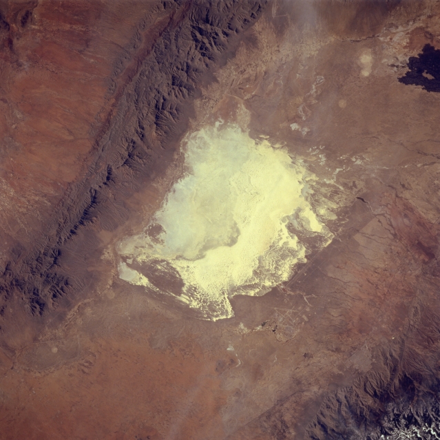 |
| STS060-083-016 White Sands National Monument, New Mexico, U.S.A. February 1994 This photograph displays the two distinct parts of the world's largest gypsum sand field, White Sands National Monument located in the Tularosa Basin in south-central New Mexico--the highly reflective eastern half, consisting of an assortment of gypsum dunes, and the western half, an alkali flat. Rain and snow from the San Andres Mountains and the Sacramento Mountains dissolve gypsum from the rocks and carry it to White Sands. The southwest corner of the monument, the lowest spot in the Tularosa Valley, changes from a dry lakebed into Lake Lucero when rain falls. The dark areas along the southern and eastern fringes of White Sands National Monument display low-growing vegetation that survives the ever-shifting gypsum sands. |
| Images: | All Available Images Low-Resolution 306k |
|
| Mission: | STS060 |
|
| Roll - Frame: | 83 - 16 |
|
| Geographical Name: | USA-NEW MEXICO |
|
| Features: | WHITE SANDS, ANDRES MTS. |
|
| Center Lat x Lon: | 33.0N x 106.5W |
|
| Film Exposure: | N | N=Normal exposure, U=Under exposed, O=Over exposed, F=out of Focus |
| Percentage of Cloud Cover-CLDP: | 0 |
|
| Camera:: | HB |
|
| Camera Tilt: | 20 | LO=Low Oblique, HO=High Oblique, NV=Near Vertical |
| Camera Focal Length: | 250 |
|
| Nadir to Photo Center Direction: | SW | The direction from the nadir to the center point, N=North, S=South, E=East, W=West |
| Stereo?: | N | Y=Yes there is an adjacent picture of the same area, N=No there isn't |
| Orbit Number: | 116 |
|
| Date: | 19940210 | YYYYMMDD |
| Time: | 201015 | GMT HHMMSS |
| Nadir Lat: | 33.8N |
Latitude of suborbital point of spacecraft |
| Nadir Lon: | 105.7W |
Longitude of suborbital point of spacecraft |
| Sun Azimuth: | 197 | Clockwise angle in degrees from north to the sun measured at the nadir point |
| Space Craft Altitude: | 191 | nautical miles |
| Sun Elevation: | 40 | Angle in degrees between the horizon and the sun, measured at the nadir point |
| Land Views: | BASIN, MOUNTAIN, DUNE |
|
| Water Views: | |
|
| Atmosphere Views: | |
|
| Man Made Views: | |
|
| City Views: | |
|
Photo is not associated with any sequences | ||
| NASA Home Page |
JSC Home Page |
JSC Digital Image Collection |
Earth Science & Remote Sensing |
|
This service is provided by the International Space Station program and the JSC Earth Science & Remote Sensing Unit, ARES Division, Exploration Integration Science Directorate.

|