
Geographic Region: USA-CALIFORNIA
Feature: SALTON SEA, AGRICULTURE
|
Geographic Region: USA-CALIFORNIA Feature: SALTON SEA, AGRICULTURE |
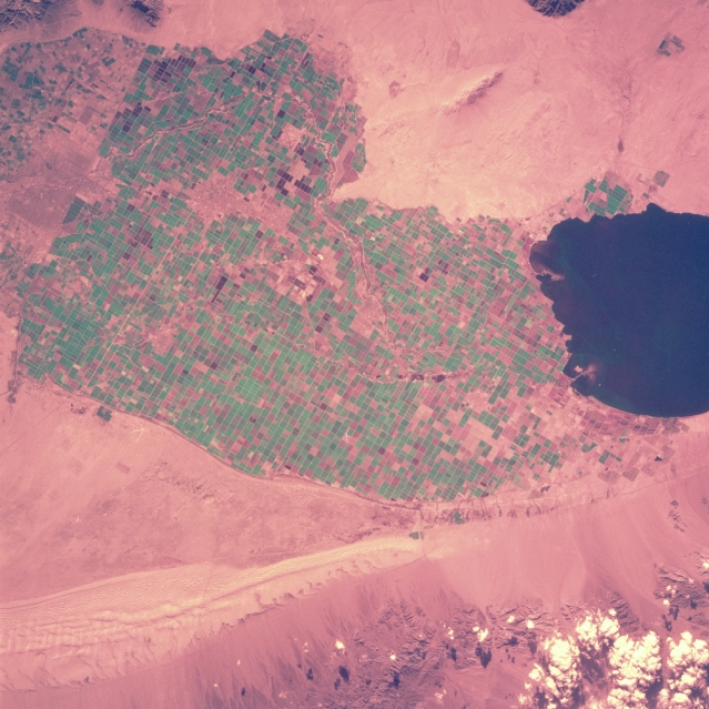 |
| STS060-105-038 Imperial Valley, California, U.S.A. February 1994 This color infrared photograph and STS-060-101-038 show the same features of the Imperial Valley (irrigated field patterns; U.S.-Mexico border; urban areas; Sand Hills; and the Salton Sea); however, two different types of film were used. The Russian film in this photograph recorded vegetation and field patterns in green; whereas, STS-060-101-038 was created with color infrared film showing vegetation in shades of red. |
| Images: | All Available Images Low-Resolution 338k |
|
| Mission: | STS060 |
|
| Roll - Frame: | 105 - 38 |
|
| Geographical Name: | USA-CALIFORNIA |
|
| Features: | SALTON SEA, AGRICULTURE |
|
| Center Lat x Lon: | 33.0N x 115.5W |
|
| Film Exposure: | N | N=Normal exposure, U=Under exposed, O=Over exposed, F=out of Focus |
| Percentage of Cloud Cover-CLDP: | 5 |
|
| Camera:: | HB |
|
| Camera Tilt: | 13 | LO=Low Oblique, HO=High Oblique, NV=Near Vertical |
| Camera Focal Length: | 250 |
|
| Nadir to Photo Center Direction: | NW | The direction from the nadir to the center point, N=North, S=South, E=East, W=West |
| Stereo?: | Y | Y=Yes there is an adjacent picture of the same area, N=No there isn't |
| Orbit Number: | 39 |
|
| Date: | 19940205 | YYYYMMDD |
| Time: | 224043 | GMT HHMMSS |
| Nadir Lat: | 32.4N |
Latitude of suborbital point of spacecraft |
| Nadir Lon: | 115.1W |
Longitude of suborbital point of spacecraft |
| Sun Azimuth: | 226 | Clockwise angle in degrees from north to the sun measured at the nadir point |
| Space Craft Altitude: | 190 | nautical miles |
| Sun Elevation: | 28 | Angle in degrees between the horizon and the sun, measured at the nadir point |
| Land Views: | VALLEY, DUNE |
|
| Water Views: | LAKE |
|
| Atmosphere Views: | |
|
| Man Made Views: | AGRICULTURE |
|
| City Views: | |
|
Photo is not associated with any sequences | ||
| NASA Home Page |
JSC Home Page |
JSC Digital Image Collection |
Earth Science & Remote Sensing |
|
This service is provided by the International Space Station program and the JSC Earth Science & Remote Sensing Unit, ARES Division, Exploration Integration Science Directorate.

|