Geographic Region: INDIA
Feature: RANN OF KUTCH
|
Geographic Region: INDIA Feature: RANN OF KUTCH |
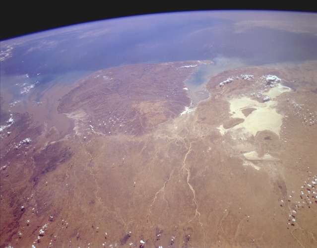 |
| STS059-L22-154 West-Central India April 1994 The Kathiawar Peninsula, the sizable promontory jutting into the Arabian Sea, is bounded on the southeast by the sediment-laden Gulf of Khambhat and on the northwest by the Gulf of Kutch. The highly reflective area north of the Gulf of Kutch is the Great Rann of Kutch, a very large salt marsh that forms the border between India and southeastern Pakistan. The Great Rann of Kutch and the Kathiawar Peninsula comprise more than 75 percent of the west-central state of Gujarat. The Kathiawar Peninsula is relatively level terrain with a slightly elevated central tableland from which all rivers arise and radiate outward. Cotton is the area's leading crop. The overall brown appearance in this springtime photograph confirms that the region deserves the tropical savanna climate classification and that the area is almost totally dependent on the monsoons for rainfall for the entire year. The Kathiawar Peninsula is also the home of the endangered Indian lion. |
| Images: | All Available Images Low-Resolution 73k |
|
| Mission: | STS059 |
|
| Roll - Frame: | L22 - 154 |
|
| Geographical Name: | INDIA |
|
| Features: | RANN OF KUTCH |
|
| Center Lat x Lon: | 22.0N x 70.0E |
|
| Film Exposure: | N | N=Normal exposure, U=Under exposed, O=Over exposed, F=out of Focus |
| Percentage of Cloud Cover-CLDP: | 5 |
|
| Camera:: | LH |
|
| Camera Tilt: | HO | LO=Low Oblique, HO=High Oblique, NV=Near Vertical |
| Camera Focal Length: | 90 |
|
| Nadir to Photo Center Direction: | SW | The direction from the nadir to the center point, N=North, S=South, E=East, W=West |
| Stereo?: | N | Y=Yes there is an adjacent picture of the same area, N=No there isn't |
| Orbit Number: | 48 |
|
| Date: | 19940412 | YYYYMMDD |
| Time: | 091420 | GMT HHMMSS |
| Nadir Lat: | 25.2N |
Latitude of suborbital point of spacecraft |
| Nadir Lon: | 73.2E |
Longitude of suborbital point of spacecraft |
| Sun Azimuth: | 247 | Clockwise angle in degrees from north to the sun measured at the nadir point |
| Space Craft Altitude: | 119 | nautical miles |
| Sun Elevation: | 56 | Angle in degrees between the horizon and the sun, measured at the nadir point |
| Land Views: | COAST, PLAIN, HILL |
|
| Water Views: | BAY, GULF, DELTA, RIVER |
|
| Atmosphere Views: | |
|
| Man Made Views: | |
|
| City Views: | |
|
Photo is not associated with any sequences | ||
| NASA Home Page |
JSC Home Page |
JSC Digital Image Collection |
Earth Science & Remote Sensing |
|
This service is provided by the International Space Station program and the JSC Earth Science & Remote Sensing Unit, ARES Division, Exploration Integration Science Directorate.

|