Geographic Region: JAPAN
Feature: KYUSHU, BAYS, MTS,RIVERS
|
Geographic Region: JAPAN Feature: KYUSHU, BAYS, MTS,RIVERS |
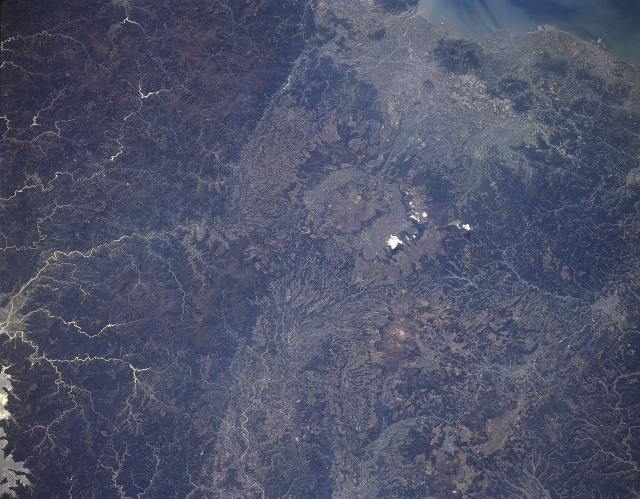 |
| STS059-L16-0BB Mount Aso Volcano, Kyushu, Japan April 1994 The central section of Japan's largest southern island, Kyushu, shows a diverse landscape of rugged, vegetated mountains (darker terrain) with lighter-colored valley areas. The thin, highly reflective lines along the left edge of the image show dendretic stream patterns, that drain southeast through the mountains. A few cities such as Kumamoto (upper center) can be located within the lighter-colored valleys and coastal plains. Careful study of this image is required to be able to identify the location of Aso Volcano, one of the world's broadest volcanoes (measuring 15 miles- 24 km in diameter). Several of the older pyroclastic flows are visible as uniform-looking features near the center of the image. There are at least 15 intra-caldera cones located in the larger caldera of Aso Volcano. The volcano is still active and emits deadly gases from time to time within the larger caldera. According to some authorities, Aso Volcano has produced more explosive eruptions that any other volcano in the world. The most recent eruption ended in 1993. |
| Images: | All Available Images Low-Resolution 294k |
|
| Mission: | STS059 |
|
| Roll - Frame: | L16 - BB |
|
| Geographical Name: | JAPAN |
|
| Features: | KYUSHU, BAYS, MTS,RIVERS |
|
| Center Lat x Lon: | 33.0N x 131.0E |
|
| Film Exposure: | N | N=Normal exposure, U=Under exposed, O=Over exposed, F=out of Focus |
| Percentage of Cloud Cover-CLDP: | 0 |
|
| Camera:: | LH |
|
| Camera Tilt: | NV | LO=Low Oblique, HO=High Oblique, NV=Near Vertical |
| Camera Focal Length: | 250 |
|
| Nadir to Photo Center Direction: | The direction from the nadir to the center point, N=North, S=South, E=East, W=West |
|
| Stereo?: | Y | Y=Yes there is an adjacent picture of the same area, N=No there isn't |
| Orbit Number: | |
|
| Date: | 199404__ | YYYYMMDD |
| Time: | GMT HHMMSS |
|
| Nadir Lat: | N |
Latitude of suborbital point of spacecraft |
| Nadir Lon: | E |
Longitude of suborbital point of spacecraft |
| Sun Azimuth: | Clockwise angle in degrees from north to the sun measured at the nadir point |
|
| Space Craft Altitude: | nautical miles |
|
| Sun Elevation: | Angle in degrees between the horizon and the sun, measured at the nadir point |
|
| Land Views: | VOLCANO, MOUNTAIN, VALLEY |
|
| Water Views: | |
|
| Atmosphere Views: | |
|
| Man Made Views: | |
|
| City Views: | |
|
Photo is not associated with any sequences | ||
| NASA Home Page |
JSC Home Page |
JSC Digital Image Collection |
Earth Science & Remote Sensing |
|
This service is provided by the International Space Station program and the JSC Earth Science & Remote Sensing Unit, ARES Division, Exploration Integration Science Directorate.

|