Geographic Region: IRELAND
Feature: LIMERICK,GALWAY BAY,MTS.
|
Geographic Region: IRELAND Feature: LIMERICK,GALWAY BAY,MTS. |
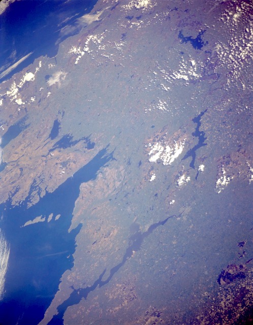 |
| STS059-L13-005 West-Central Ireland April 1994 The west-central region of Ireland is presented in this low-oblique, north-looking photograph. Numerous lakes are scattered across the landscape as reminders of the continental glaciers that once covered the entire region. Glaciation resulted in much of Ireland having thin soil that will not support significant vegetation growth despite 40 to 80 inches (100 to 200 centimeters) of annual precipitation. The western coastal area is classified as humid temperate with cool summers and no specific dry season. The higher elevations of 1000 to 2000 feet (300 to 600 meters) usually appear tan or light brown, which indicates a lack of forested vegetation. Pastoralism is the dominant agricultural pursuit in west-central Ireland. This photograph shows a representative section of the west coast of Ireland, which contains peninsulas, bays, and islands. Viewing clockwise from north of Galway Bay are several large lakes--Corrib and Mask immediately north of the bay, Ree to the northeast, and elongated Derg south of Ree. Several cities are barely visible--Galway at the northeast end of Galway Bay and, to the south, Shannon on the north bank of the Shannon River; and Limerick on the south bank of the Shannon River. |
| Images: | All Available Images Low-Resolution 109k |
|
| Mission: | STS059 |
|
| Roll - Frame: | L13 - 5 |
|
| Geographical Name: | IRELAND |
|
| Features: | LIMERICK,GALWAY BAY,MTS. |
|
| Center Lat x Lon: | 53.0N x 8.5W |
|
| Film Exposure: | N | N=Normal exposure, U=Under exposed, O=Over exposed, F=out of Focus |
| Percentage of Cloud Cover-CLDP: | 10 |
|
| Camera:: | LH |
|
| Camera Tilt: | 49 | LO=Low Oblique, HO=High Oblique, NV=Near Vertical |
| Camera Focal Length: | 90 |
|
| Nadir to Photo Center Direction: | N | The direction from the nadir to the center point, N=North, S=South, E=East, W=West |
| Stereo?: | N | Y=Yes there is an adjacent picture of the same area, N=No there isn't |
| Orbit Number: | 130 |
|
| Date: | 19940417 | YYYYMMDD |
| Time: | 102128 | GMT HHMMSS |
| Nadir Lat: | 50.9N |
Latitude of suborbital point of spacecraft |
| Nadir Lon: | 8W |
Longitude of suborbital point of spacecraft |
| Sun Azimuth: | 135 | Clockwise angle in degrees from north to the sun measured at the nadir point |
| Space Craft Altitude: | 113 | nautical miles |
| Sun Elevation: | 42 | Angle in degrees between the horizon and the sun, measured at the nadir point |
| Land Views: | ISLAND, HILL, COAST |
|
| Water Views: | OCEAN, BAY, RIVER |
|
| Atmosphere Views: | |
|
| Man Made Views: | |
|
| City Views: | |
|
Photo is not associated with any sequences | ||
| NASA Home Page |
JSC Home Page |
JSC Digital Image Collection |
Earth Science & Remote Sensing |
|
This service is provided by the International Space Station program and the JSC Earth Science & Remote Sensing Unit, ARES Division, Exploration Integration Science Directorate.

|