
Geographic Region: USA-ARIZONA
Feature: PHOENIX AREA
|
Geographic Region: USA-ARIZONA Feature: PHOENIX AREA |
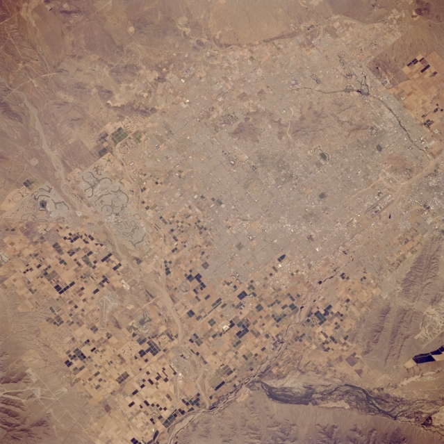 |
| STS059-086-060 Phoenix, Arizona, U.S.A. April 1994 Street and highway grid patterns in metropolitan Phoenix are visible in this photograph. The population of this arid, hot region grew rapidly in the 1960s and 1970s as Arizona emerged as an industrial state. Northwest of downtown Phoenix, the distinctive, curving lines of the golf course and lakes of the Sun City retirement community are apparent; the dual runways of Phoenix's Sky Harbor International Airport near the southern edge of the city are barely discernible. Large, rectangular, cultivated field patterns can be distinguished west of the city. South of Phoenix, South Mountain and the braided stream channels of the Gila River can be identified. |
| Images: | All Available Images Low-Resolution 336k |
|
| Mission: | STS059 |
|
| Roll - Frame: | 86 - 60 |
|
| Geographical Name: | USA-ARIZONA |
|
| Features: | PHOENIX AREA |
|
| Center Lat x Lon: | 33.5N x 112W |
|
| Film Exposure: | N | N=Normal exposure, U=Under exposed, O=Over exposed, F=out of Focus |
| Percentage of Cloud Cover-CLDP: | 0 |
|
| Camera:: | HB |
|
| Camera Tilt: | 26 | LO=Low Oblique, HO=High Oblique, NV=Near Vertical |
| Camera Focal Length: | 250 |
|
| Nadir to Photo Center Direction: | E | The direction from the nadir to the center point, N=North, S=South, E=East, W=West |
| Stereo?: | N | Y=Yes there is an adjacent picture of the same area, N=No there isn't |
| Orbit Number: | 40 |
|
| Date: | 19940411 | YYYYMMDD |
| Time: | 212107 | GMT HHMMSS |
| Nadir Lat: | 33.2N |
Latitude of suborbital point of spacecraft |
| Nadir Lon: | 112.9W |
Longitude of suborbital point of spacecraft |
| Sun Azimuth: | 232 | Clockwise angle in degrees from north to the sun measured at the nadir point |
| Space Craft Altitude: | 119 | nautical miles |
| Sun Elevation: | 55 | Angle in degrees between the horizon and the sun, measured at the nadir point |
| Land Views: | MOUNTAIN |
|
| Water Views: | RIVER |
|
| Atmosphere Views: | |
|
| Man Made Views: | URBAN AREA, AIRPORT |
|
| City Views: | PHOENIX |
|
Photo is not associated with any sequences | ||
| NASA Home Page |
JSC Home Page |
JSC Digital Image Collection |
Earth Science & Remote Sensing |
|
This service is provided by the International Space Station program and the JSC Earth Science & Remote Sensing Unit, ARES Division, Exploration Integration Science Directorate.

|