Geographic Region: SAUDI ARABIA
Feature: AD DAHNA, ARRIYAD
|
Geographic Region: SAUDI ARABIA Feature: AD DAHNA, ARRIYAD |
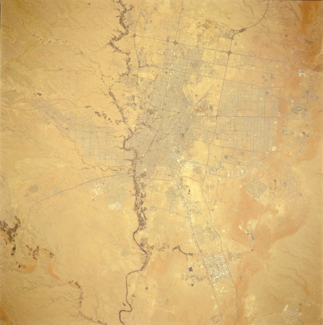 |
| STS059-225-044 Riyadh (Ar Riyad), Saudi Arabia April 1994 The capital city of Riyadh, with an estimated population of more than 2.5 million, lies within a wide east-west economic belt that crosses the Arabian Peninsula. The "waist" of the peninsula extends from the port city of Ad Dammam on the western shore of the Persian Gulf, westward to Riyadh, and then to Makkah (Mecca) and the Red Sea port city of Jiddah (Jeddah). This economic belt boasts one of the world's most modern and highly effective internal transportation and communication networks. Riyadh, situated in an oasis, has served as the focal point for desert trade and travel for many years. The darker, linear features in this photograph are numerous highways and streets traversing Riyadh. Riyadh International Airport, with its V-shaped runways, is located north of the city. The meandering line of dark vegetation along the southwest side of the city is the Wadi (watercourse) Hanifah. This and similar photographs taken from space provide a great opportunity to measure and monitor growth of a rapidly expanding desert urban area with very little obscuring vegetation. |
| Images: | All Available Images Low-Resolution 99k |
|
| Mission: | STS059 |
|
| Roll - Frame: | 225 - 44 |
|
| Geographical Name: | SAUDI ARABIA |
|
| Features: | AD DAHNA, ARRIYAD |
|
| Center Lat x Lon: | 24.5N x 47.0E |
|
| Film Exposure: | N | N=Normal exposure, U=Under exposed, O=Over exposed, F=out of Focus |
| Percentage of Cloud Cover-CLDP: | 0 |
|
| Camera:: | HB |
|
| Camera Tilt: | 10 | LO=Low Oblique, HO=High Oblique, NV=Near Vertical |
| Camera Focal Length: | 250 |
|
| Nadir to Photo Center Direction: | S | The direction from the nadir to the center point, N=North, S=South, E=East, W=West |
| Stereo?: | Y | Y=Yes there is an adjacent picture of the same area, N=No there isn't |
| Orbit Number: | 145 |
|
| Date: | 19940418 | YYYYMMDD |
| Time: | 084040 | GMT HHMMSS |
| Nadir Lat: | 24.8N |
Latitude of suborbital point of spacecraft |
| Nadir Lon: | 47.1E |
Longitude of suborbital point of spacecraft |
| Sun Azimuth: | 169 | Clockwise angle in degrees from north to the sun measured at the nadir point |
| Space Craft Altitude: | 113 | nautical miles |
| Sun Elevation: | 76 | Angle in degrees between the horizon and the sun, measured at the nadir point |
| Land Views: | DESERT, PLATEAU, DUNE |
|
| Water Views: | |
|
| Atmosphere Views: | |
|
| Man Made Views: | |
|
| City Views: | RIYADH |
|
Photo is not associated with any sequences | ||
| NASA Home Page |
JSC Home Page |
JSC Digital Image Collection |
Earth Science & Remote Sensing |
|
This service is provided by the International Space Station program and the JSC Earth Science & Remote Sensing Unit, ARES Division, Exploration Integration Science Directorate.

|