Geographic Region: AUSTRALIA-Q
Feature: DIAMANTINA RIVER
|
Geographic Region: AUSTRALIA-Q Feature: DIAMANTINA RIVER |
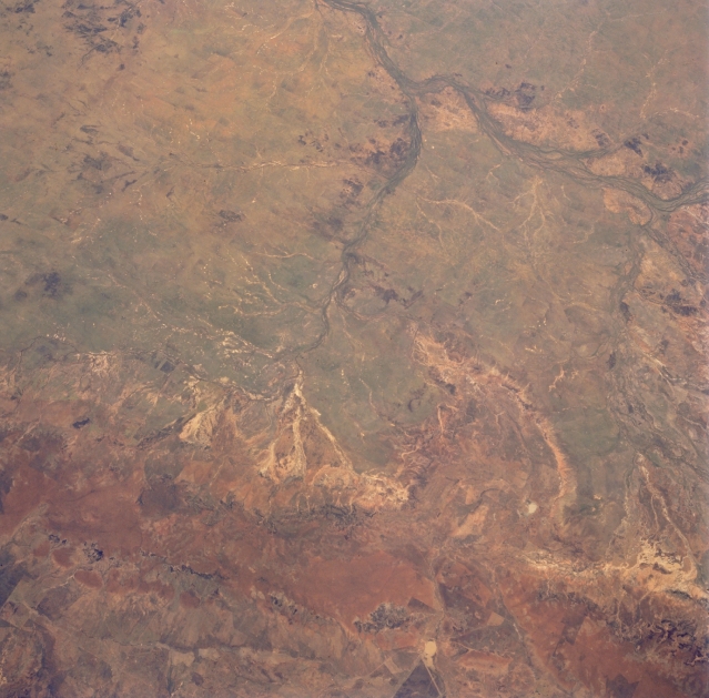 |
| STS059-203-093 Aramac Creek, Queensland, Australia April 1994 Numerous tributaries, including Aramac Creek (center of image), can be traced across the semiarid landscape as they drain westward into the Thomson River (top right) northeast of the Outback city of Longreach (just off the image at top center). The general location of the smaller central Queensland town, Aramac, can be ascertained by its location along the Aramac Creek. Most of this part of the Great Artesian Basin consists of grassy plains with a few rounded hills scattered throughout the landscape. There are no perennial streams in any of the interior drainage basins of arid central Australia. When it does rain streams may flow for hours, days, or rarely for as long as a month. The broad reddish swath of terrain across the bottom of the photo is part of the Great Dividing Range of mountains. |
| Images: | All Available Images Low-Resolution 314k |
|
| Mission: | STS059 |
|
| Roll - Frame: | 203 - 93 |
|
| Geographical Name: | AUSTRALIA-Q |
|
| Features: | DIAMANTINA RIVER |
|
| Center Lat x Lon: | 24S x 143.0E |
|
| Film Exposure: | N | N=Normal exposure, U=Under exposed, O=Over exposed, F=out of Focus |
| Percentage of Cloud Cover-CLDP: | 0 |
|
| Camera:: | HB |
|
| Camera Tilt: | LO | LO=Low Oblique, HO=High Oblique, NV=Near Vertical |
| Camera Focal Length: | 100 |
|
| Nadir to Photo Center Direction: | The direction from the nadir to the center point, N=North, S=South, E=East, W=West |
|
| Stereo?: | N | Y=Yes there is an adjacent picture of the same area, N=No there isn't |
| Orbit Number: | |
|
| Date: | 199404__ | YYYYMMDD |
| Time: | GMT HHMMSS |
|
| Nadir Lat: | N |
Latitude of suborbital point of spacecraft |
| Nadir Lon: | E |
Longitude of suborbital point of spacecraft |
| Sun Azimuth: | Clockwise angle in degrees from north to the sun measured at the nadir point |
|
| Space Craft Altitude: | nautical miles |
|
| Sun Elevation: | Angle in degrees between the horizon and the sun, measured at the nadir point |
|
| Land Views: | BASIN |
|
| Water Views: | RIVER |
|
| Atmosphere Views: | |
|
| Man Made Views: | |
|
| City Views: | |
|
Photo is not associated with any sequences | ||
| NASA Home Page |
JSC Home Page |
JSC Digital Image Collection |
Earth Science & Remote Sensing |
|
This service is provided by the International Space Station program and the JSC Earth Science & Remote Sensing Unit, ARES Division, Exploration Integration Science Directorate.

|