Geographic Region: DENMARK
Feature: LIMSFJORDEN
|
Geographic Region: DENMARK Feature: LIMSFJORDEN |
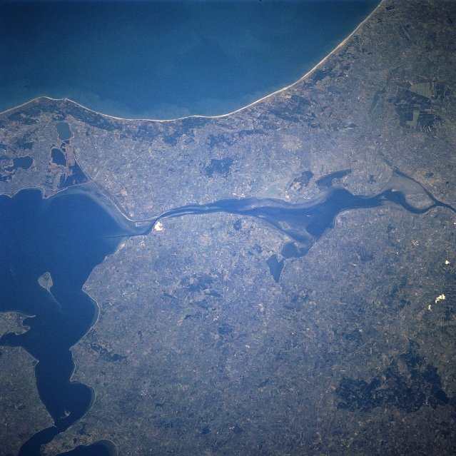 |
| STS059-202-010 Lim Fjord, Denmark April 1994 A portion of Lim Fjord waterway can be seen in this north-looking view. The waterway is 110 miles (180 km) long and cuts across the northern Jutland Peninsula of Denmark eventually connecting the North Sea (not visible on the image) with the Kattegat (not visible on the image). The Lim Fjord is irregular in shape, forming the Logstor (left center), a lagoon 15 miles (24 km) wide, in its middle section. Jammer Bay is located along the upper left and center of the image. |
| Images: | All Available Images Low-Resolution 361k |
|
| Mission: | STS059 |
|
| Roll - Frame: | 202 - 10 |
|
| Geographical Name: | DENMARK |
|
| Features: | LIMSFJORDEN |
|
| Center Lat x Lon: | 57.0N x 9.0E |
|
| Film Exposure: | N | N=Normal exposure, U=Under exposed, O=Over exposed, F=out of Focus |
| Percentage of Cloud Cover-CLDP: | 0 |
|
| Camera:: | HB |
|
| Camera Tilt: | 39 | LO=Low Oblique, HO=High Oblique, NV=Near Vertical |
| Camera Focal Length: | 250 |
|
| Nadir to Photo Center Direction: | NW | The direction from the nadir to the center point, N=North, S=South, E=East, W=West |
| Stereo?: | Y | Y=Yes there is an adjacent picture of the same area, N=No there isn't |
| Orbit Number: | 31 |
|
| Date: | 19940411 | YYYYMMDD |
| Time: | 074647 | GMT HHMMSS |
| Nadir Lat: | 55.7N |
Latitude of suborbital point of spacecraft |
| Nadir Lon: | 9.9E |
Longitude of suborbital point of spacecraft |
| Sun Azimuth: | 117 | Clockwise angle in degrees from north to the sun measured at the nadir point |
| Space Craft Altitude: | 118 | nautical miles |
| Sun Elevation: | 27 | Angle in degrees between the horizon and the sun, measured at the nadir point |
| Land Views: | PLAIN |
|
| Water Views: | SEA, CHANNEL, LAGOON |
|
| Atmosphere Views: | |
|
| Man Made Views: | AGRICULTURE |
|
| City Views: | |
|
Photo is not associated with any sequences | ||
| NASA Home Page |
JSC Home Page |
JSC Digital Image Collection |
Earth Science & Remote Sensing |
|
This service is provided by the International Space Station program and the JSC Earth Science & Remote Sensing Unit, ARES Division, Exploration Integration Science Directorate.

|