
Geographic Region: USA-KANSAS
Feature: KANSAS CITY, MISSOURI RIVER
|
Geographic Region: USA-KANSAS Feature: KANSAS CITY, MISSOURI RIVER |
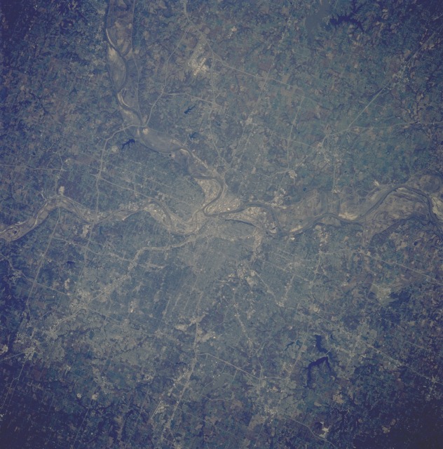 |
| STS058-088-051 Kansas City, Kansas and Missouri, U.S.A. October 1993 Metropolitan Kansas City, with a population of more than 750 000, is the dominant feature in this near-vertical photograph. The central city is located near the junction of the Kansas and Missouri Rivers (conspicuous near the center of the photograph). The Kansas City area is one of the largest commercial, industrial, and cultural centers in the midwestern United States. The region is a huge marketplace for wheat, hay, seed, and poultry. Other commercial and industrial businesses include large stockyards, packing houses, grain elevators, food-processing establishments, oil refineries, chemical plants, steel mills, soap and farm machine factories, automobile assembly plants, railroad shops, aerospace equipment, and computers. The effects of the summer flood of 1993 in the midwest are visible in the floodplains of both the Kansas and Missouri Rivers--most obvious in the photograph of the Missouri River floodplain northwest of the city and portions of the Kansas River floodplain west of the city. Silt, sand, mud, and other debris cover areas that were agricultural fields growing grains and other crops before the flood. Discernible manmade features are the major runway of the Richards-Gebaur Air Force Base south of the city; the major runways of the Kansas City International Airport north-northwest of the city; and numerous highway systems traversing the Kansas City region. During the 1800s, Kansas City was a starting place for many westward expeditions. |
| Images: | All Available Images Low-Resolution 135k |
|
| Mission: | STS058 |
|
| Roll - Frame: | 88 - 51 |
|
| Geographical Name: | USA-KANSAS |
|
| Features: | KANSAS CITY, MISSOURI RIVER |
|
| Center Lat x Lon: | 39.0N x 94.5W |
|
| Film Exposure: | N | N=Normal exposure, U=Under exposed, O=Over exposed, F=out of Focus |
| Percentage of Cloud Cover-CLDP: | 0 |
|
| Camera:: | HB |
|
| Camera Tilt: | 21 | LO=Low Oblique, HO=High Oblique, NV=Near Vertical |
| Camera Focal Length: | 250 |
|
| Nadir to Photo Center Direction: | W | The direction from the nadir to the center point, N=North, S=South, E=East, W=West |
| Stereo?: | N | Y=Yes there is an adjacent picture of the same area, N=No there isn't |
| Orbit Number: | 66 |
|
| Date: | 19931022 | YYYYMMDD |
| Time: | 164257 | GMT HHMMSS |
| Nadir Lat: | 39.1N |
Latitude of suborbital point of spacecraft |
| Nadir Lon: | 93.5W |
Longitude of suborbital point of spacecraft |
| Sun Azimuth: | 157 | Clockwise angle in degrees from north to the sun measured at the nadir point |
| Space Craft Altitude: | 155 | nautical miles |
| Sun Elevation: | 37 | Angle in degrees between the horizon and the sun, measured at the nadir point |
| Land Views: | PLAIN, VALLEY |
|
| Water Views: | RIVER |
|
| Atmosphere Views: | |
|
| Man Made Views: | URBAN AREA, AIRPORT, AGRICULTURE |
|
| City Views: | KANSAS CITY |
|
Photo is not associated with any sequences | ||
| NASA Home Page |
JSC Home Page |
JSC Digital Image Collection |
Earth Science & Remote Sensing |
|
This service is provided by the International Space Station program and the JSC Earth Science & Remote Sensing Unit, ARES Division, Exploration Integration Science Directorate.

|