
Geographic Region: USA-MARYLAND
Feature: WASHINGTON, D. C.
|
Geographic Region: USA-MARYLAND Feature: WASHINGTON, D. C. |
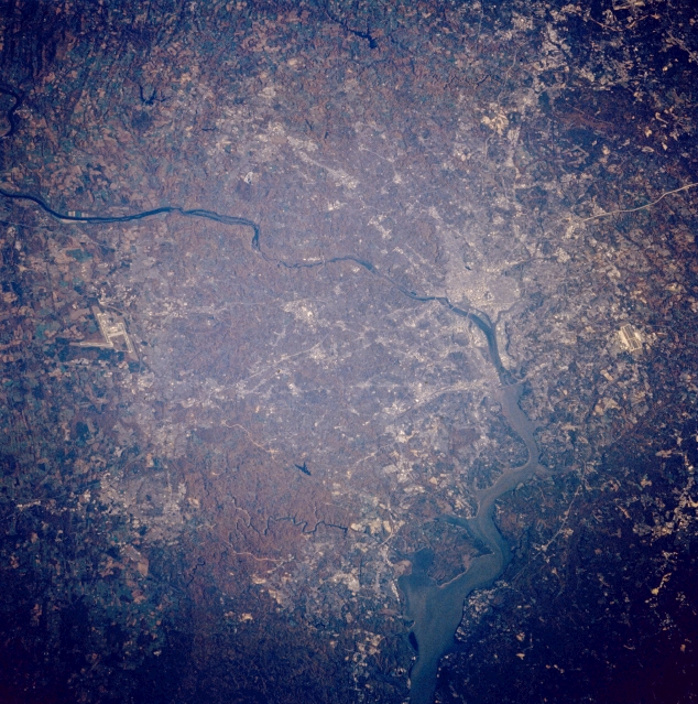 |
| STS058-081-008 Washington, D. C., Potomac River, Virginia, U.S.A. October 1993 The Potomac River can be seen entering the scene from the northwest midway between the left center and upper left, going through Washington, D.C., and exiting the scene to the south near the center bottom, of this mostly north-looking low-oblique view. The Potomac passes over the Great Falls (not discernible) just to the northwest of Washington, D.C., and enters a tidal estuary just to the south of the city. The city of Washington, D.C., visible to the right of the center of the image, is the capital of the United States. The runways of Dulles International Airport can be seen near the left center of the image. The north-south runways of Andrews Air Force Base are visible near the right center of the image. |
| Images: | All Available Images Low-Resolution 400k |
|
| Mission: | STS058 |
|
| Roll - Frame: | 81 - 8 |
|
| Geographical Name: | USA-MARYLAND |
|
| Features: | WASHINGTON, D. C. |
|
| Center Lat x Lon: | 39.0N x 77W |
|
| Film Exposure: | U | N=Normal exposure, U=Under exposed, O=Over exposed, F=out of Focus |
| Percentage of Cloud Cover-CLDP: | 0 |
|
| Camera:: | HB |
|
| Camera Tilt: | 40 | LO=Low Oblique, HO=High Oblique, NV=Near Vertical |
| Camera Focal Length: | 100 |
|
| Nadir to Photo Center Direction: | NE | The direction from the nadir to the center point, N=North, S=South, E=East, W=West |
| Stereo?: | Y | Y=Yes there is an adjacent picture of the same area, N=No there isn't |
| Orbit Number: | 96 |
|
| Date: | 19931024 | YYYYMMDD |
| Time: | 133925 | GMT HHMMSS |
| Nadir Lat: | 37.4N |
Latitude of suborbital point of spacecraft |
| Nadir Lon: | 78.3W |
Longitude of suborbital point of spacecraft |
| Sun Azimuth: | 126 | Clockwise angle in degrees from north to the sun measured at the nadir point |
| Space Craft Altitude: | 146 | nautical miles |
| Sun Elevation: | 22 | Angle in degrees between the horizon and the sun, measured at the nadir point |
| Land Views: | PLAIN, FOREST |
|
| Water Views: | RIVER, ESTUARY |
|
| Atmosphere Views: | |
|
| Man Made Views: | URBAN AREA, AIRPORT |
|
| City Views: | WASHINGTON D.C. |
|
Photo is not associated with any sequences | ||
| NASA Home Page |
JSC Home Page |
JSC Digital Image Collection |
Earth Science & Remote Sensing |
|
This service is provided by the International Space Station program and the JSC Earth Science & Remote Sensing Unit, ARES Division, Exploration Integration Science Directorate.

|