Geographic Region: JAPAN
Feature: COAST NEAR SENDAL
|
Geographic Region: JAPAN Feature: COAST NEAR SENDAL |
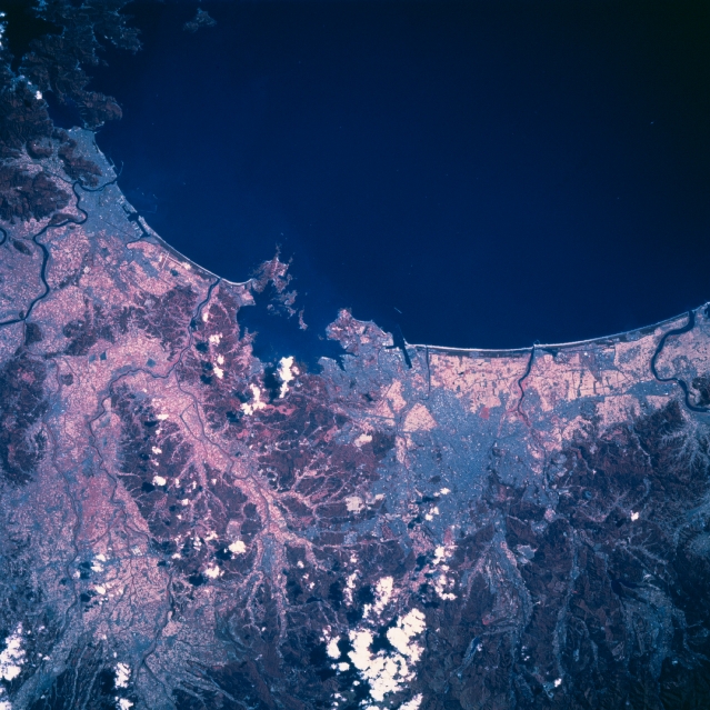 |
| STS058-111-032 Sendai Area, Honshu, Japan October 1993 Several rivers (thin, dark lines) traverse the coastal plains (generally lighter-color landscape) in the vicinity of Sendai along the northeast coast of Honshu Island. The color infrared properties of this image delimits the forested, low mountainous terrain (deeper reds) from the coastal plains that are drained by the Kitakami River, the Abukuma River, and smaller river systems. The mouths of the Kitakami River and the Abukuma River (dark, meandering lines) are visible along the left and right edges, respectively, of the image. Both rivers flow into Sendai Bay (large, dark body of water). The city of Sendai, while it is barely discernible, can be located inland from the coast and southwest of the small bay near the center of the picture. |
| Images: | All Available Images Low-Resolution 344k |
|
| Mission: | STS058 |
|
| Roll - Frame: | 111 - 32 |
|
| Geographical Name: | JAPAN |
|
| Features: | COAST NEAR SENDAL |
|
| Center Lat x Lon: | 38.0N x 141.0E |
|
| Film Exposure: | N | N=Normal exposure, U=Under exposed, O=Over exposed, F=out of Focus |
| Percentage of Cloud Cover-CLDP: | 5 |
|
| Camera:: | HB |
|
| Camera Tilt: | 16 | LO=Low Oblique, HO=High Oblique, NV=Near Vertical |
| Camera Focal Length: | 250 |
|
| Nadir to Photo Center Direction: | W | The direction from the nadir to the center point, N=North, S=South, E=East, W=West |
| Stereo?: | N | Y=Yes there is an adjacent picture of the same area, N=No there isn't |
| Orbit Number: | 24 |
|
| Date: | 19931020 | YYYYMMDD |
| Time: | 013745 | GMT HHMMSS |
| Nadir Lat: | 38.2N |
Latitude of suborbital point of spacecraft |
| Nadir Lon: | 141.7E |
Longitude of suborbital point of spacecraft |
| Sun Azimuth: | 167 | Clockwise angle in degrees from north to the sun measured at the nadir point |
| Space Craft Altitude: | 152 | nautical miles |
| Sun Elevation: | 41 | Angle in degrees between the horizon and the sun, measured at the nadir point |
| Land Views: | PLAIN, MOUNTAIN, FOREST |
|
| Water Views: | RIVER, BAY |
|
| Atmosphere Views: | |
|
| Man Made Views: | |
|
| City Views: | |
|
Photo is not associated with any sequences | ||
| NASA Home Page |
JSC Home Page |
JSC Digital Image Collection |
Earth Science & Remote Sensing |
|
This service is provided by the International Space Station program and the JSC Earth Science & Remote Sensing Unit, ARES Division, Exploration Integration Science Directorate.

|