Geographic Region: JAPAN
Feature: MT. FUJI VOLCANO
|
Geographic Region: JAPAN Feature: MT. FUJI VOLCANO |
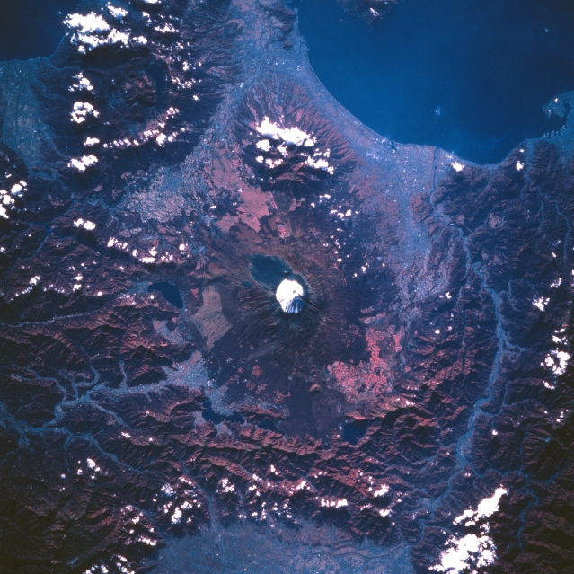 |
| STS058-110-036 Mount Fuji Area, Honshu, Japan October 1993 Located approximately 60 miles (95 km) southwest of Tokyo, Mt. Fuji (snow capped peak, center of image) is Japan's most sacred mountain. Mt. Fuji, an almost symmetrical stratovolcano, is Japan's tallest mountain at 12388 feet (3776 meters) above sea level. Although scattered clouds obscure some of the mountainous terrain in the region, the color infrared image (green vegetation is shown as shades of red) helps to identify the forested, steep sloped mountains. The different shades of red indicate the extent of green vegetation from the forested mountains (deep reds) to the cultivated fields (pinkish colors) in the valleys and along the coast of Suruga Bay (upper right). The Fuji River Valley is visible (linear, light colored feature) as it passes through a mountainous area near the western side of the volcano (right side of image). The pink area at the bottom (center) of the image is part of the Kofu Valley. The angular-looking, lighter-colored landscape on the flanks of Fuji Volcano is the result of clear cutting logging operations. |
| Images: | All Available Images Low-Resolution 369k |
|
| Mission: | STS058 |
|
| Roll - Frame: | 110 - 36 |
|
| Geographical Name: | JAPAN |
|
| Features: | MT. FUJI VOLCANO |
|
| Center Lat x Lon: | 35.5N x 138.5E |
|
| Film Exposure: | N | N=Normal exposure, U=Under exposed, O=Over exposed, F=out of Focus |
| Percentage of Cloud Cover-CLDP: | 10 |
|
| Camera:: | HB |
|
| Camera Tilt: | 22 | LO=Low Oblique, HO=High Oblique, NV=Near Vertical |
| Camera Focal Length: | 250 |
|
| Nadir to Photo Center Direction: | SW | The direction from the nadir to the center point, N=North, S=South, E=East, W=West |
| Stereo?: | N | Y=Yes there is an adjacent picture of the same area, N=No there isn't |
| Orbit Number: | 55 |
|
| Date: | 19931022 | YYYYMMDD |
| Time: | 000755 | GMT HHMMSS |
| Nadir Lat: | 36.4N |
Latitude of suborbital point of spacecraft |
| Nadir Lon: | 139.0E |
Longitude of suborbital point of spacecraft |
| Sun Azimuth: | 138 | Clockwise angle in degrees from north to the sun measured at the nadir point |
| Space Craft Altitude: | 150 | nautical miles |
| Sun Elevation: | 32 | Angle in degrees between the horizon and the sun, measured at the nadir point |
| Land Views: | MOUNTAIN, VALLEY, VOLCANO |
|
| Water Views: | RIVER, BAY |
|
| Atmosphere Views: | |
|
| Man Made Views: | |
|
| City Views: | |
|
Photo is not associated with any sequences | ||
| NASA Home Page |
JSC Home Page |
JSC Digital Image Collection |
Earth Science & Remote Sensing |
|
This service is provided by the International Space Station program and the JSC Earth Science & Remote Sensing Unit, ARES Division, Exploration Integration Science Directorate.

|