Geographic Region: USA-TEXAS
Feature: MATAGORDA BAY, PORT LAVACA
|
Geographic Region: USA-TEXAS Feature: MATAGORDA BAY, PORT LAVACA |
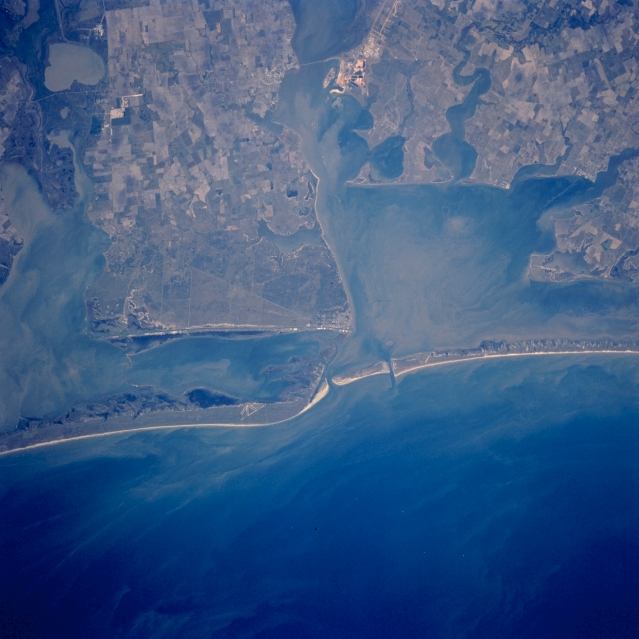 |
| STS058-101-056 Matagorda Bay and San Antonio Bay, Texas, U.S.A. October 1993 Matagorda Bay and San Antonio Bay, two of the larger bays of central coastal Texas, are visible in this near-vertical photograph. Sandy barrier islands have created a series of estuaries that separate the Gulf of Mexico and the Intracoastal Waterway. Runways of an abandoned airstrip are barely visible near the northeast end of Matagorda Island, which lies south of Matagorda Peninsula, the sliver of barrier beach that extends southwest. Substantial suspended sediments are widespread throughout the estuaries and the shoreside waters of the gulf. Northwest of Matagorda Bay are Lavaca Bay and Port Lavaca, southwest of a bridge crossing the bay. Small Port O'Connor, southeast of Port Lavaca on the western edge of Matagorda Bay, is discernible on the northeastern point of land on the large peninsula that separates Matagorda Bay and San Antonio Bay. Some cultivated field patterns are apparent on the mainland. |
| Images: | All Available Images Low-Resolution 289k |
|
| Mission: | STS058 |
|
| Roll - Frame: | 101 - 56 |
|
| Geographical Name: | USA-TEXAS |
|
| Features: | MATAGORDA BAY, PORT LAVACA |
|
| Center Lat x Lon: | 28.5N x 96.5W |
|
| Film Exposure: | N | N=Normal exposure, U=Under exposed, O=Over exposed, F=out of Focus |
| Percentage of Cloud Cover-CLDP: | 0 |
|
| Camera:: | HB |
|
| Camera Tilt: | 31 | LO=Low Oblique, HO=High Oblique, NV=Near Vertical |
| Camera Focal Length: | 250 |
|
| Nadir to Photo Center Direction: | E | The direction from the nadir to the center point, N=North, S=South, E=East, W=West |
| Stereo?: | N | Y=Yes there is an adjacent picture of the same area, N=No there isn't |
| Orbit Number: | 84 |
|
| Date: | 19931023 | YYYYMMDD |
| Time: | 195500 | GMT HHMMSS |
| Nadir Lat: | 28.3N |
Latitude of suborbital point of spacecraft |
| Nadir Lon: | 98W |
Longitude of suborbital point of spacecraft |
| Sun Azimuth: | 214 | Clockwise angle in degrees from north to the sun measured at the nadir point |
| Space Craft Altitude: | 152 | nautical miles |
| Sun Elevation: | 44 | Angle in degrees between the horizon and the sun, measured at the nadir point |
| Land Views: | COAST, ISLAND, PLAIN |
|
| Water Views: | BAY, CHANNEL, GULF |
|
| Atmosphere Views: | |
|
| Man Made Views: | |
|
| City Views: | |
|
Photo is not associated with any sequences | ||
| NASA Home Page |
JSC Home Page |
JSC Digital Image Collection |
Earth Science & Remote Sensing |
|
This service is provided by the International Space Station program and the JSC Earth Science & Remote Sensing Unit, ARES Division, Exploration Integration Science Directorate.

|