Geographic Region: INDIA
Feature: GODAVARI RIVER DELTA
|
Geographic Region: INDIA Feature: GODAVARI RIVER DELTA |
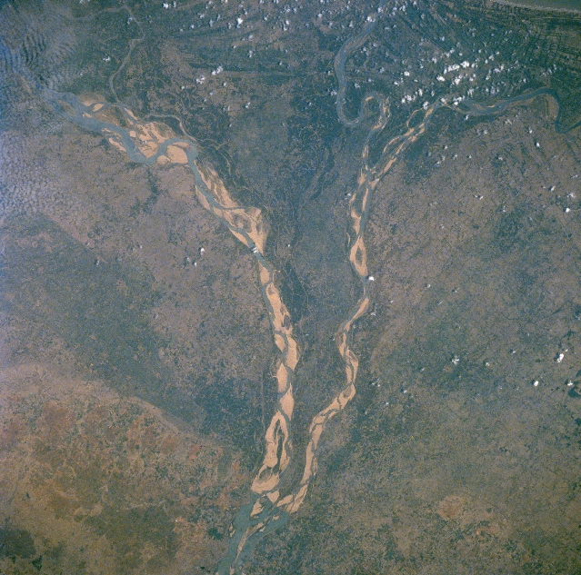 |
| STS055-074-00T Godavari River/Delta, India May 1993 The southeasterly draining Godavari River has created a classic fan-shaped delta along the southeast coast of India. The wet, summer monsoon of India has a dramatic impact on the volume and flow rate of water that the Godavari River can accommodate. By observing this image that is pre-summer monsoon, the volume of water, as well as the flow rate into and through the delta is minimal. The source area for the Godavari River is northeast of Bombay (on the western edge of the Deccan Plateau) and in spite of the river's substantial length of 870 miles (1400 km) only moderate rainfall amounts across the Deccan Plateau allow modest discharge rates into the Bay of Bengal. The fertile delta is however, one of India's main rice growing regions. The location of the cultural capital, Rajahmundry, is barely visible on the east bank of the Godavari River, slightly south of where the main river channel splits into two distributary channels. The lighter-colored features in the floodplains of the meandering channels are sandbars. |
| Images: | All Available Images Low-Resolution 390k |
|
| Mission: | STS055 |
|
| Roll - Frame: | 74 - T |
|
| Geographical Name: | INDIA |
|
| Features: | GODAVARI RIVER DELTA |
|
| Center Lat x Lon: | 16.5N x 82.0E |
|
| Film Exposure: | N | N=Normal exposure, U=Under exposed, O=Over exposed, F=out of Focus |
| Percentage of Cloud Cover-CLDP: | 5 |
|
| Camera:: | HB |
|
| Camera Tilt: | LO | LO=Low Oblique, HO=High Oblique, NV=Near Vertical |
| Camera Focal Length: | 250 |
|
| Nadir to Photo Center Direction: | The direction from the nadir to the center point, N=North, S=South, E=East, W=West |
|
| Stereo?: | Y | Y=Yes there is an adjacent picture of the same area, N=No there isn't |
| Orbit Number: | |
|
| Date: | 1993____ | YYYYMMDD |
| Time: | GMT HHMMSS |
|
| Nadir Lat: | N |
Latitude of suborbital point of spacecraft |
| Nadir Lon: | E |
Longitude of suborbital point of spacecraft |
| Sun Azimuth: | Clockwise angle in degrees from north to the sun measured at the nadir point |
|
| Space Craft Altitude: | nautical miles |
|
| Sun Elevation: | Angle in degrees between the horizon and the sun, measured at the nadir point |
|
| Land Views: | PLAIN |
|
| Water Views: | RIVER, DELTA |
|
| Atmosphere Views: | |
|
| Man Made Views: | |
|
| City Views: | |
|
Photo is not associated with any sequences | ||
| NASA Home Page |
JSC Home Page |
JSC Digital Image Collection |
Earth Science & Remote Sensing |
|
This service is provided by the International Space Station program and the JSC Earth Science & Remote Sensing Unit, ARES Division, Exploration Integration Science Directorate.

|