 Photo #: STS055-152A-104 Date: May 1993
Geographic Region: NEPAL
Feature: HIMALAYA RA,MARSHES

 Photo #: STS055-152A-104 Date: May 1993 Photo #: STS055-152A-104 Date: May 1993Geographic Region: NEPAL Feature: HIMALAYA RA,MARSHES |
 |
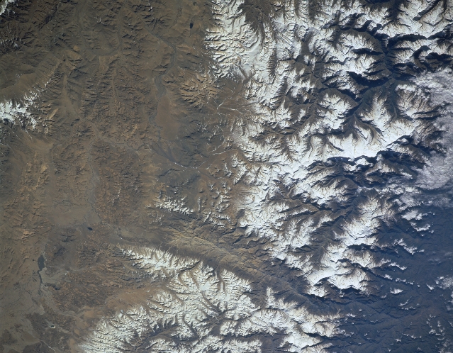
| STS055-152A-104 Himalayas, Nepal May 1993 A section of the worlds most massive and tallest mountains, the Himalayas, are shown in this image that includes north central Nepal (left) and the south central Tibetan Autonomous Region of China (right). The swath of snow-covered mountains averages about 28 miles (45 km) in north-south distance. While most of the rugged mountainous chain does not have many north-south ground corridors or passes, this image does contain the Kali River Valley that created a sizeable gorge through the Himalayas (linear-looking north-south structure slightly above center of the image). All of the major rivers in Nepal actually preceded the formation of the mountains. As the Himalayas grew in elevation through the interaction of the Indian plate and Eurasian plate, the rivers cut through the mountain and subsequently created deep, transverse gorges. The Kali River, one of seven tributaries of the Narayani River, flows southward through such a gorge. The concentrated area of whiteness (lower left quadrant) is Manaslu I peak. At 26755 feet (8155 meters) this peak is one of the world's tallest. The elongated dark feature (near upper right corner) is a lake that is located within a swampy landscape on the Tibetan Plateau (about 15000 feet - 4572 meters - above sea level). |
| Images: | All Available Images Low-Resolution 317k |
|
| Mission: | STS055 |
|
| Roll - Frame: | 152A - 104 |
|
| Geographical Name: | NEPAL |
|
| Features: | HIMALAYA RA,MARSHES |
|
| Center Lat x Lon: | 28.5N x 84.0E |
|
| Film Exposure: | N | N=Normal exposure, U=Under exposed, O=Over exposed, F=out of Focus |
| Percentage of Cloud Cover-CLDP: | 0 |
|
| Camera:: | LH |
|
| Camera Tilt: | 46 | LO=Low Oblique, HO=High Oblique, NV=Near Vertical |
| Camera Focal Length: | 250 |
|
| Nadir to Photo Center Direction: | W | The direction from the nadir to the center point, N=North, S=South, E=East, W=West |
| Stereo?: | N | Y=Yes there is an adjacent picture of the same area, N=No there isn't |
| Orbit Number: | 72 |
|
| Date: | 19930501 | YYYYMMDD |
| Time: | 014914 | GMT HHMMSS |
| Nadir Lat: | 28.3N |
Latitude of suborbital point of spacecraft |
| Nadir Lon: | 86.8E |
Longitude of suborbital point of spacecraft |
| Sun Azimuth: | 88 | Clockwise angle in degrees from north to the sun measured at the nadir point |
| Space Craft Altitude: | 164 | nautical miles |
| Sun Elevation: | 29 | Angle in degrees between the horizon and the sun, measured at the nadir point |
| Land Views: | MOUNTAIN, VALLEY, FAULT |
|
| Water Views: | RIVER |
|
| Atmosphere Views: | |
|
| Man Made Views: | |
|
| City Views: | |
|
Photo is not associated with any sequences | ||
| NASA Home Page |
JSC Home Page |
JSC Digital Image Collection |
Earth Science & Remote Sensing |
|
|