Geographic Region: REPUBLIC SOUTH AFRICA
Feature: TRANSVAAL DRAKENSBERG
|
Geographic Region: REPUBLIC SOUTH AFRICA Feature: TRANSVAAL DRAKENSBERG |
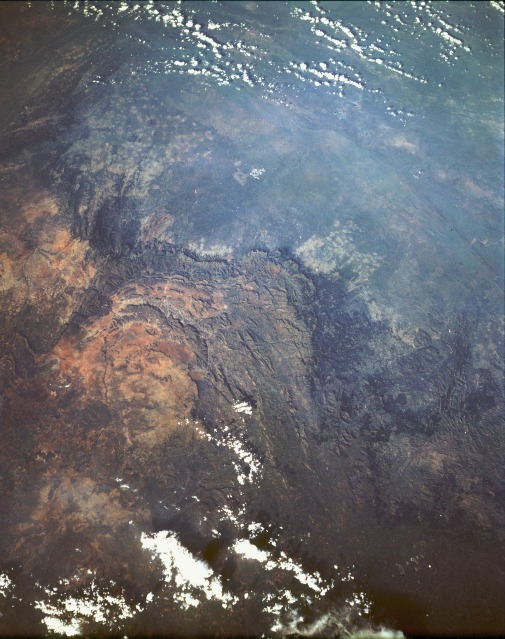 |
| STS054-151-019 Drakensberg Mountains, South Africa January 1993 The Drakensberg Mountains near the southeast coast of South Africa form an impressive barrier between the broad, basin-like interior plateau of South Africa and the coastal plains. Part of the great escarpment that extends from southern Zimbabwe in a generally northeast-southwest-trending arc to Cape Town, the Drakensberg Range has been described as dramatically beautiful. This photograph, with an almost 3-dimensional quality, captures a small section of that beauty as the plateau elevation drops to the east in near-vertical escarpments, with the vertical drops looking like a series of downward steps before giving way to rolling grasslands that gradually slope to the Indian Ocean. The complex structure of this range has a thick, underlying series of sandstones formed 180 to 260 million years ago. Approximately 150 million years ago, lava began intruding through fissures in the sandstone rocks, spreading out in enormous horizontal layers. This photograph shows the result of weathering and erosion on the basalt plateau--the mountain terrain carved into jagged peaks separated by deep valleys and ravines. While most of the plateau drains westward, several smaller rivers flow eastward and plunge rapidly down to the Indian Ocean. |
| Images: | All Available Images Low-Resolution 119k |
|
| Mission: | STS054 |
|
| Roll - Frame: | 151 - 19 |
|
| Geographical Name: | REPUBLIC SOUTH AFRICA |
|
| Features: | TRANSVAAL DRAKENSBERG |
|
| Center Lat x Lon: | 25S x 31.5E |
|
| Film Exposure: | N | N=Normal exposure, U=Under exposed, O=Over exposed, F=out of Focus |
| Percentage of Cloud Cover-CLDP: | 10 |
|
| Camera:: | LH |
|
| Camera Tilt: | LO | LO=Low Oblique, HO=High Oblique, NV=Near Vertical |
| Camera Focal Length: | 90 |
|
| Nadir to Photo Center Direction: | The direction from the nadir to the center point, N=North, S=South, E=East, W=West |
|
| Stereo?: | N | Y=Yes there is an adjacent picture of the same area, N=No there isn't |
| Orbit Number: | |
|
| Date: | 199301__ | YYYYMMDD |
| Time: | GMT HHMMSS |
|
| Nadir Lat: | N |
Latitude of suborbital point of spacecraft |
| Nadir Lon: | E |
Longitude of suborbital point of spacecraft |
| Sun Azimuth: | Clockwise angle in degrees from north to the sun measured at the nadir point |
|
| Space Craft Altitude: | nautical miles |
|
| Sun Elevation: | Angle in degrees between the horizon and the sun, measured at the nadir point |
|
| Land Views: | MOUNTAIN, ESCARPMENT, VALLEY, FOREST, PLATEAU |
|
| Water Views: | RIVER |
|
| Atmosphere Views: | |
|
| Man Made Views: | AGRICULTURE |
|
| City Views: | |
|
Photo is not associated with any sequences | ||
| NASA Home Page |
JSC Home Page |
JSC Digital Image Collection |
Earth Science & Remote Sensing |
|
This service is provided by the International Space Station program and the JSC Earth Science & Remote Sensing Unit, ARES Division, Exploration Integration Science Directorate.

|