Geographic Region: EGYPT
Feature: SUEZ CANAL AREA
|
Geographic Region: EGYPT Feature: SUEZ CANAL AREA |
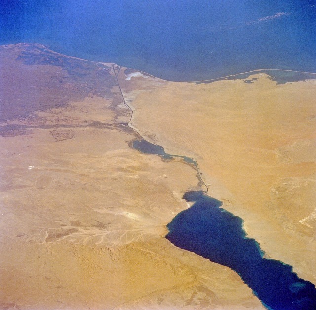 |
| STS052-074-058 Suez Canal, Egypt October 1992 The entire length of Egypt's Suez Canal (dark north-south line) is visible in this low-oblique, northeast-looking photograph. Extending from the port city of Suez in the south to Port Said in the north, a distance of approximately 100 miles (160 kilometers), the canal connects the Red Sea with the eastern Mediterranean Sea. The minimum width of the canal is 179 feet (55 meters), and the minimum depth of the channel is 40 feet (12 meters). Ships entering the canal from the south pass through the Gulf of Suez, Little Bitter Lake, Great Bitter Lake, and into the main body of the canal. The sandy desert of the northwest Sinai Peninsula occupies the territory east of the canal, and the large dark area west of the canal is the eastern extent of the Nile River Delta. The dendrite drainage feature along the northwest side of the Gulf of Suez is Khafuri Wadi. The narrow swath of green extending east-west on the west side of the canal is a strip of irrigated farmland that borders the Ismailia Canal, which connects Cairo with the Suez Canal at the city of Ismailia. Many center-pivot irrigation field patterns are visible in a roughly rectangular area south of the Ismailia Canal. |
| Images: | All Available Images Low-Resolution 116k |
|
| Mission: | STS052 |
|
| Roll - Frame: | 74 - 58 |
|
| Geographical Name: | EGYPT |
|
| Features: | SUEZ CANAL AREA |
|
| Center Lat x Lon: | 30.0N x 32.5E |
|
| Film Exposure: | N | N=Normal exposure, U=Under exposed, O=Over exposed, F=out of Focus |
| Percentage of Cloud Cover-CLDP: | 0 |
|
| Camera:: | HB |
|
| Camera Tilt: | LO | LO=Low Oblique, HO=High Oblique, NV=Near Vertical |
| Camera Focal Length: | 50 |
|
| Nadir to Photo Center Direction: | N | The direction from the nadir to the center point, N=North, S=South, E=East, W=West |
| Stereo?: | Y | Y=Yes there is an adjacent picture of the same area, N=No there isn't |
| Orbit Number: | 13 |
|
| Date: | 19921023 | YYYYMMDD |
| Time: | 112605 | GMT HHMMSS |
| Nadir Lat: | 25.2N |
Latitude of suborbital point of spacecraft |
| Nadir Lon: | 31.4E |
Longitude of suborbital point of spacecraft |
| Sun Azimuth: | 219 | Clockwise angle in degrees from north to the sun measured at the nadir point |
| Space Craft Altitude: | 163 | nautical miles |
| Sun Elevation: | 45 | Angle in degrees between the horizon and the sun, measured at the nadir point |
| Land Views: | DESERT, PLAIN |
|
| Water Views: | SEA, GULF, LAKE |
|
| Atmosphere Views: | |
|
| Man Made Views: | AGRICULTURE, PIVOT IRRIGATION |
|
| City Views: | |
|
Photo is not associated with any sequences | ||
| NASA Home Page |
JSC Home Page |
JSC Digital Image Collection |
Earth Science & Remote Sensing |
|
This service is provided by the International Space Station program and the JSC Earth Science & Remote Sensing Unit, ARES Division, Exploration Integration Science Directorate.

|