Geographic Region: AUSTRALIA-Q
Feature: GEORGINA RIVER
|
Geographic Region: AUSTRALIA-Q Feature: GEORGINA RIVER |
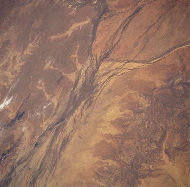 |
| STS051-101-054 Georgina River, Queensland, Australia September 1993 The Georgina River's floodplain widens substantially south of the very small Outback town of Boulia in southwest Queensland. This picture shows the merging area of three of Australia's many ephermal rivers that drain towards the interior of the continent. From the top right (northeast) the Hamilton River and its small delta merges with the Burke River (drains southward from the north) and the Georgina River (from the northwest). Keep in mind that these rivers only have limited water flow when there is sufficient rainfall in the basin areas north of this region. The darker-looking landscape in the lower right quadrant is the slightly elevated terrain that separates the Georgina drainage basin from the Diamantina drainage basin to the east. The darker looking areas in the scene are where more vegetative cover exists, mainly grasslands. The lighter-looking landscape shows areas where erosion is greatest--not permitting vegetation to get established. |
| Images: | All Available Images Low-Resolution 310k |
|
| Mission: | STS051 |
|
| Roll - Frame: | 101 - 54 |
|
| Geographical Name: | AUSTRALIA-Q |
|
| Features: | GEORGINA RIVER |
|
| Center Lat x Lon: | 23.5S x 140.0E |
|
| Film Exposure: | N | N=Normal exposure, U=Under exposed, O=Over exposed, F=out of Focus |
| Percentage of Cloud Cover-CLDP: | 5 |
|
| Camera:: | HB |
|
| Camera Tilt: | 49 | LO=Low Oblique, HO=High Oblique, NV=Near Vertical |
| Camera Focal Length: | 100 |
|
| Nadir to Photo Center Direction: | W | The direction from the nadir to the center point, N=North, S=South, E=East, W=West |
| Stereo?: | Y | Y=Yes there is an adjacent picture of the same area, N=No there isn't |
| Orbit Number: | 47 |
|
| Date: | 19930915 | YYYYMMDD |
| Time: | 050724 | GMT HHMMSS |
| Nadir Lat: | 24S |
Latitude of suborbital point of spacecraft |
| Nadir Lon: | 143.0E |
Longitude of suborbital point of spacecraft |
| Sun Azimuth: | 298 | Clockwise angle in degrees from north to the sun measured at the nadir point |
| Space Craft Altitude: | 161 | nautical miles |
| Sun Elevation: | 42 | Angle in degrees between the horizon and the sun, measured at the nadir point |
| Land Views: | DESERT, FLOOD PLAIN |
|
| Water Views: | RIVER |
|
| Atmosphere Views: | |
|
| Man Made Views: | |
|
| City Views: | |
|
Photo is not associated with any sequences | ||
| NASA Home Page |
JSC Home Page |
JSC Digital Image Collection |
Earth Science & Remote Sensing |
|
This service is provided by the International Space Station program and the JSC Earth Science & Remote Sensing Unit, ARES Division, Exploration Integration Science Directorate.

|