Geographic Region: AUSTRALIA-Q
Feature: HAMILTON RIVER
|
Geographic Region: AUSTRALIA-Q Feature: HAMILTON RIVER |
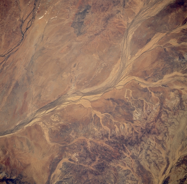 |
| STS051-101-052 Hamilton River, Queensland, Australia September 1993 The Hamilton River is one of many ephermal streams that drains southward towards the interior of the Australian continent and specifically into the Simpson Desert of southwestern Queensland and part of the Northern territory. The multi-braided channels of a fairly broad floodplain of the Hamilton River display a typical appearance for many of the intermittently flowing rivers that traverse the flat to gently undulating terrain in this arid environment. Several light-colored (less-vegetated) erosional tributaries are visible along the southeastern side of the river. A short section of the drainage channels of the Burke River (dark lines) are visible in the upper left corner of the image and the headwaters area of Pot Jostler Creek which drains into the Diamantina River Basin is visible in the lower right corner of the picture. |
| Images: | All Available Images Low-Resolution 326k |
|
| Mission: | STS051 |
|
| Roll - Frame: | 101 - 52 |
|
| Geographical Name: | AUSTRALIA-Q |
|
| Features: | HAMILTON RIVER |
|
| Center Lat x Lon: | 23S x 140.5E |
|
| Film Exposure: | N | N=Normal exposure, U=Under exposed, O=Over exposed, F=out of Focus |
| Percentage of Cloud Cover-CLDP: | 0 |
|
| Camera:: | HB |
|
| Camera Tilt: | 36 | LO=Low Oblique, HO=High Oblique, NV=Near Vertical |
| Camera Focal Length: | 100 |
|
| Nadir to Photo Center Direction: | W | The direction from the nadir to the center point, N=North, S=South, E=East, W=West |
| Stereo?: | Y | Y=Yes there is an adjacent picture of the same area, N=No there isn't |
| Orbit Number: | 47 |
|
| Date: | 19930915 | YYYYMMDD |
| Time: | 050714 | GMT HHMMSS |
| Nadir Lat: | 23.8S |
Latitude of suborbital point of spacecraft |
| Nadir Lon: | 142.3E |
Longitude of suborbital point of spacecraft |
| Sun Azimuth: | 299 | Clockwise angle in degrees from north to the sun measured at the nadir point |
| Space Craft Altitude: | 161 | nautical miles |
| Sun Elevation: | 43 | Angle in degrees between the horizon and the sun, measured at the nadir point |
| Land Views: | DESERT |
|
| Water Views: | RIVER |
|
| Atmosphere Views: | |
|
| Man Made Views: | |
|
| City Views: | |
|
Photo is not associated with any sequences | ||
| NASA Home Page |
JSC Home Page |
JSC Digital Image Collection |
Earth Science & Remote Sensing |
|
This service is provided by the International Space Station program and the JSC Earth Science & Remote Sensing Unit, ARES Division, Exploration Integration Science Directorate.

|