Geographic Region: INDONESIA
Feature: SUMBAWA, TAMBORO VOLCANO
|
Geographic Region: INDONESIA Feature: SUMBAWA, TAMBORO VOLCANO |
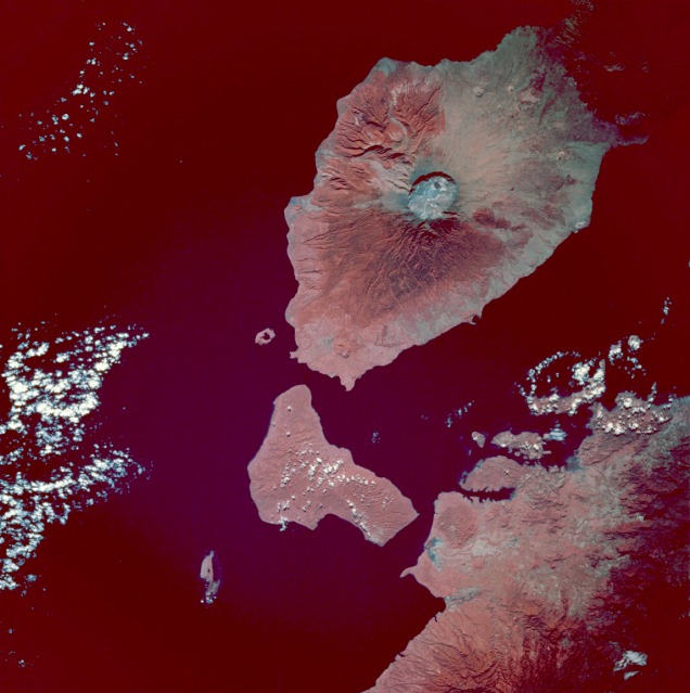 |
| STS049-97-54 Tambora Volcano, Sumbawa Island, Indonesia May 1992 The most striking geologic feature in this photograph is the large circular Tambora Volcano caldera, the diameter of which is slightly more than 3 miles (5 kilometers). Prior to the disastrous eruption of 1815 when the volcano blew away most of its top, Tambora's summit was approximately 13 000 feet (4000 meters) above sea level. The present elevation of the caldera rim is more than 9000 feet (2700 meters) above sea level. Many geologists and volcanologists rank the 1815 eruption among the 10 most explosive eruptions of the modern era. Tambora, a classic stratovolcano with steep slopes and a symmetrical shape, is located on the north-central coast of Sumbawa Island, Indonesia, which is bordered on the north by the Flores Sea and on the southwest by Teluk Saleh Bay. Color infrared film, which displays green vegetation in varying shades of red, accentuates the distribution patterns of dense tropical vegetation surrounding the volcano and other land areas in the photograph. |
| Images: | All Available Images Low-Resolution 97k |
|
| Mission: | STS049 |
|
| Roll - Frame: | 97 - 54 |
|
| Geographical Name: | INDONESIA |
|
| Features: | SUMBAWA, TAMBORO VOLCANO |
|
| Center Lat x Lon: | 8S x 118.0E |
|
| Film Exposure: | N | N=Normal exposure, U=Under exposed, O=Over exposed, F=out of Focus |
| Percentage of Cloud Cover-CLDP: | 5 |
|
| Camera:: | HB |
|
| Camera Tilt: | 28 | LO=Low Oblique, HO=High Oblique, NV=Near Vertical |
| Camera Focal Length: | 250 |
|
| Nadir to Photo Center Direction: | SW | The direction from the nadir to the center point, N=North, S=South, E=East, W=West |
| Stereo?: | Y | Y=Yes there is an adjacent picture of the same area, N=No there isn't |
| Orbit Number: | 81 |
|
| Date: | 19920513 | YYYYMMDD |
| Time: | 005425 | GMT HHMMSS |
| Nadir Lat: | 7S |
Latitude of suborbital point of spacecraft |
| Nadir Lon: | 119.4E |
Longitude of suborbital point of spacecraft |
| Sun Azimuth: | 60 | Clockwise angle in degrees from north to the sun measured at the nadir point |
| Space Craft Altitude: | 198 | nautical miles |
| Sun Elevation: | 38 | Angle in degrees between the horizon and the sun, measured at the nadir point |
| Land Views: | ISLAND, VOLCANO, CRATER, COAST |
|
| Water Views: | |
|
| Atmosphere Views: | |
|
| Man Made Views: | |
|
| City Views: | |
|
Photo is not associated with any sequences | ||
| NASA Home Page |
JSC Home Page |
JSC Digital Image Collection |
Earth Science & Remote Sensing |
|
This service is provided by the International Space Station program and the JSC Earth Science & Remote Sensing Unit, ARES Division, Exploration Integration Science Directorate.

|