Geographic Region: ITALY
Feature: COAST,NAPLES,MT. VESUVIUS
|
Geographic Region: ITALY Feature: COAST,NAPLES,MT. VESUVIUS |
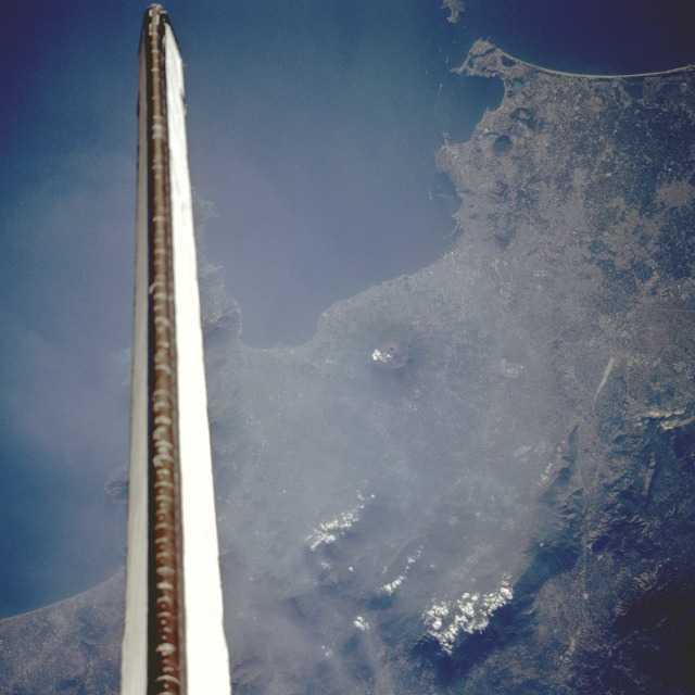 |
| STS047-094-023 Vesuvius Volcano and Naples, Italy September 1992 This low-oblique, west-looking photograph shows Vesuvius (center of the photograph), the only active volcano on the European mainland, whose last eruption occurred in 1944. Vesuvius, a complex stratovolcano located east of Naples, has erupted more than 50 times since its most famous eruption in 79 A. D. that buried the cities of Pompeii and Herculaneum. Monte Somma, the ridge that half circles the central cone of Vesuvius, is the remains of an ancient volcano that erupted and collapsed, the lower slopes of which are extremely fertile and are dotted with many small villages and vineyards. Naples, west of Vesuvius, is a major seaport with shipyards (piers are visible in the photograph) and a major commercial, industrial, cultural, and tourism center. Manufactures include iron and steel, oil refinery products, chemicals, textiles, food products, electrical machinery, aircraft and railroad locomotive parts, and handicrafts. Metropolitan Naples has a population of more than 1.4 million. West of Naples lies the Phlegraean Fields, a cluster of 20 craters with many hot springs and fumaroles. Monte Nuovo, a cinder cone with a small crater lake, was formed by a violent eruption in 1538. Although the volcano has remained dormant since that eruption, many small earthquakes during the last 100 years cause concern about future volcanic activity. |
| Images: | All Available Images Low-Resolution 88k |
|
| Mission: | STS047 |
|
| Roll - Frame: | 94 - 23 |
|
| Geographical Name: | ITALY |
|
| Features: | COAST,NAPLES,MT. VESUVIUS |
|
| Center Lat x Lon: | 41.0N x 14.0E |
|
| Film Exposure: | N | N=Normal exposure, U=Under exposed, O=Over exposed, F=out of Focus |
| Percentage of Cloud Cover-CLDP: | 5 |
|
| Camera:: | HB |
|
| Camera Tilt: | 20 | LO=Low Oblique, HO=High Oblique, NV=Near Vertical |
| Camera Focal Length: | 250 |
|
| Nadir to Photo Center Direction: | W | The direction from the nadir to the center point, N=North, S=South, E=East, W=West |
| Stereo?: | Y | Y=Yes there is an adjacent picture of the same area, N=No there isn't |
| Orbit Number: | 49 |
|
| Date: | 19920915 | YYYYMMDD |
| Time: | 151902 | GMT HHMMSS |
| Nadir Lat: | 40.8N |
Latitude of suborbital point of spacecraft |
| Nadir Lon: | 15.0E |
Longitude of suborbital point of spacecraft |
| Sun Azimuth: | 256 | Clockwise angle in degrees from north to the sun measured at the nadir point |
| Space Craft Altitude: | 169 | nautical miles |
| Sun Elevation: | 21 | Angle in degrees between the horizon and the sun, measured at the nadir point |
| Land Views: | VOLCANO, CRATER |
|
| Water Views: | BAY |
|
| Atmosphere Views: | SMOG |
|
| Man Made Views: | URBAN AREA |
|
| City Views: | |
|
Photo is not associated with any sequences | ||
| NASA Home Page |
JSC Home Page |
JSC Digital Image Collection |
Earth Science & Remote Sensing |
|
This service is provided by the International Space Station program and the JSC Earth Science & Remote Sensing Unit, ARES Division, Exploration Integration Science Directorate.

|