Geographic Region: RUSSIAN FEDERATION
Feature: S. END OF KAMCHATKA
|
Geographic Region: RUSSIAN FEDERATION Feature: S. END OF KAMCHATKA |
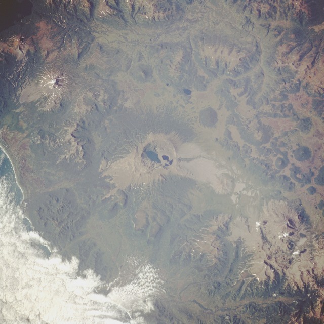 |
| STS047-90-93 Volcanoes, Kamchatka Peninsula, Russia September 1992 Kamchatka Peninsula in extreme eastern Russia offers a living laboratory for the study of volcanoes. Experts estimate that of approximately 80 volcanoes on Kamchatka, about 33 are classified as active. This photograph of the southeast coast of Kamchatka Peninsula shows a very rugged volcanic landscape without snow cover, which can conceal some of the more subtle volcanic features. A very large, water-filled caldera is clearly visible in the center of the photograph. The maximum elevation of the rim of this caldera is 3504 feet (1068 meters). Twenty miles (32 kilometers) northeast of this caldera stands Mount Khodutka, a stratovolcano [peak elevation is 6857 feet (2090 meters)], and 20 miles (32 kilometers) southwest of the large caldera stands Mount Zheltovskaya, another stratovolcano, rising 6142 feet (1870 meters) above sea level. Numerous smaller volcanoes can be identified by their dark, (forested) generally circular shapes. (Refer to photographs STS068-214-43 and STS068-273-33 that show Klyuchevskaya Volcano erupting in October 1994.) |
| Images: | All Available Images Low-Resolution 116k |
|
| Mission: | STS047 |
|
| Roll - Frame: | 90 - 93 |
|
| Geographical Name: | RUSSIAN FEDERATION |
|
| Features: | S. END OF KAMCHATKA |
|
| Center Lat x Lon: | 52.0N x 157.5E |
|
| Film Exposure: | N | N=Normal exposure, U=Under exposed, O=Over exposed, F=out of Focus |
| Percentage of Cloud Cover-CLDP: | 10 |
|
| Camera:: | HB |
|
| Camera Tilt: | 23 | LO=Low Oblique, HO=High Oblique, NV=Near Vertical |
| Camera Focal Length: | 250 |
|
| Nadir to Photo Center Direction: | W | The direction from the nadir to the center point, N=North, S=South, E=East, W=West |
| Stereo?: | Y | Y=Yes there is an adjacent picture of the same area, N=No there isn't |
| Orbit Number: | 39 |
|
| Date: | 19920914 | YYYYMMDD |
| Time: | 235835 | GMT HHMMSS |
| Nadir Lat: | 52.1N |
Latitude of suborbital point of spacecraft |
| Nadir Lon: | 158.7E |
Longitude of suborbital point of spacecraft |
| Sun Azimuth: | 155 | Clockwise angle in degrees from north to the sun measured at the nadir point |
| Space Craft Altitude: | 170 | nautical miles |
| Sun Elevation: | 38 | Angle in degrees between the horizon and the sun, measured at the nadir point |
| Land Views: | VOLCANO, CRATER |
|
| Water Views: | |
|
| Atmosphere Views: | |
|
| Man Made Views: | |
|
| City Views: | |
|
Photo is not associated with any sequences | ||
| NASA Home Page |
JSC Home Page |
JSC Digital Image Collection |
Earth Science & Remote Sensing |
|
This service is provided by the International Space Station program and the JSC Earth Science & Remote Sensing Unit, ARES Division, Exploration Integration Science Directorate.

|