Geographic Region: RUSSIAN FEDERATION
Feature: KURIL I,KHARIMKOTAN I.
|
Geographic Region: RUSSIAN FEDERATION Feature: KURIL I,KHARIMKOTAN I. |
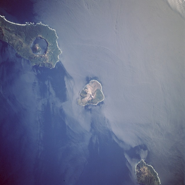 |
| STS047-90-85 Onekotan and Kharmkotan, Kurile Islands, Russia September 1992 The Kurile Islands are a chain of more than thirty volcanic islands stretching 775 miles (1245 km)between the Kamchatka Peninsula to the north and the Japanese Island of Hokkaido to the south, and are part of the "Ring of Fire" that encircles the Pacific Ocean. The Kurile islands are very young and active volcanoes, evidenced by their very pristine volcanic forms. This view shows three volcanic islands of the Kuriles, Onekotan (top left), Kharmkotan (center), and Shiashkotan. The low sunlight highlights the steep volcanic shapes on these islands. For scale, the small, circular volcano located within the caldera lake on Onekotan Island (upper left) reaches an altitude of 4367 feet (1330 meters). |
| Images: | All Available Images Low-Resolution 81k |
|
| Mission: | STS047 |
|
| Roll - Frame: | 90 - 85 |
|
| Geographical Name: | RUSSIAN FEDERATION |
|
| Features: | KURIL I,KHARIMKOTAN I. |
|
| Center Lat x Lon: | 49.0N x 154.5E |
|
| Film Exposure: | N | N=Normal exposure, U=Under exposed, O=Over exposed, F=out of Focus |
| Percentage of Cloud Cover-CLDP: | 0 |
|
| Camera:: | HB |
|
| Camera Tilt: | 27 | LO=Low Oblique, HO=High Oblique, NV=Near Vertical |
| Camera Focal Length: | 250 |
|
| Nadir to Photo Center Direction: | SE | The direction from the nadir to the center point, N=North, S=South, E=East, W=West |
| Stereo?: | Y | Y=Yes there is an adjacent picture of the same area, N=No there isn't |
| Orbit Number: | 39 |
|
| Date: | 19920914 | YYYYMMDD |
| Time: | 235738 | GMT HHMMSS |
| Nadir Lat: | 50.2N |
Latitude of suborbital point of spacecraft |
| Nadir Lon: | 153.7E |
Longitude of suborbital point of spacecraft |
| Sun Azimuth: | 148 | Clockwise angle in degrees from north to the sun measured at the nadir point |
| Space Craft Altitude: | 170 | nautical miles |
| Sun Elevation: | 38 | Angle in degrees between the horizon and the sun, measured at the nadir point |
| Land Views: | ISLAND, VOLCANO |
|
| Water Views: | ISLAND WAKE, OCEAN |
|
| Atmosphere Views: | |
|
| Man Made Views: | |
|
| City Views: | |
|
Photo is not associated with any sequences | ||
| NASA Home Page |
JSC Home Page |
JSC Digital Image Collection |
Earth Science & Remote Sensing |
|
This service is provided by the International Space Station program and the JSC Earth Science & Remote Sensing Unit, ARES Division, Exploration Integration Science Directorate.

|