
Geographic Region: KYRGYZSTAN
Feature: LAKE ISSYK-KUL
|
Geographic Region: KYRGYZSTAN Feature: LAKE ISSYK-KUL |
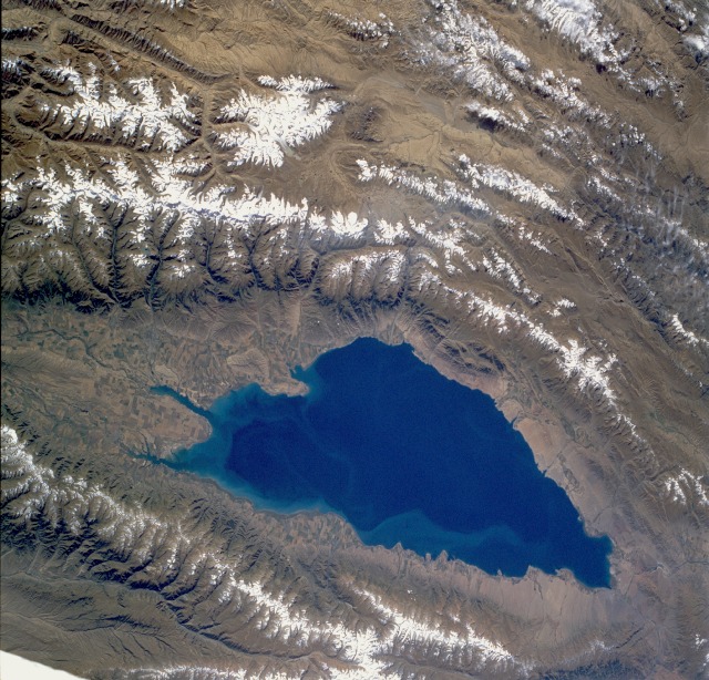 |
| STS047-077-082 Lake Issyk-Kul', Kyrgystan September 1992 Lake Issyk-Kul', located in northeastern Kyrgystan, is a brackish lake surrounded by many of the lesser mountain ranges that comprise the formidable Tien Shan Range. Issyk-Kul', whose surface is approximately 1 mile (1.6 kilometers) above sea level, is an extremely deep lake, measuring 2303 feet (700 meters) at its deepest point. It is approximately 115 miles (195 kilometers) long and 38 miles (60 kilometers) at its maximum width. Cultivated field patterns can be seen around the periphery of the lake, with the most concentrated areas on the delta that has formed along the eastern end of the lake. The snowcapped mountain ranges to the north and south have peaks that vary in elevation from 13 000 to more than 18 000 feet (3960 to 5490 meters) above sea level. Practically all of the water needed for agriculture is obtained from the runoff from glaciers and snowmelt. |
| Images: | All Available Images Low-Resolution 165k |
|
| Mission: | STS047 |
|
| Roll - Frame: | 77 - 82 |
|
| Geographical Name: | KYRGYZSTAN |
|
| Features: | LAKE ISSYK-KUL |
|
| Center Lat x Lon: | 42.5N x 77.5E |
|
| Film Exposure: | N | N=Normal exposure, U=Under exposed, O=Over exposed, F=out of Focus |
| Percentage of Cloud Cover-CLDP: | 0 |
|
| Camera:: | HB |
|
| Camera Tilt: | 40 | LO=Low Oblique, HO=High Oblique, NV=Near Vertical |
| Camera Focal Length: | 100 |
|
| Nadir to Photo Center Direction: | W | The direction from the nadir to the center point, N=North, S=South, E=East, W=West |
| Stereo?: | Y | Y=Yes there is an adjacent picture of the same area, N=No there isn't |
| Orbit Number: | 26 |
|
| Date: | 19920914 | YYYYMMDD |
| Time: | 041712 | GMT HHMMSS |
| Nadir Lat: | 43.1N |
Latitude of suborbital point of spacecraft |
| Nadir Lon: | 79.8E |
Longitude of suborbital point of spacecraft |
| Sun Azimuth: | 132 | Clockwise angle in degrees from north to the sun measured at the nadir point |
| Space Craft Altitude: | 169 | nautical miles |
| Sun Elevation: | 41 | Angle in degrees between the horizon and the sun, measured at the nadir point |
| Land Views: | MOUNTAIN, VALLEY, GLACIER |
|
| Water Views: | LAKE, RIVER |
|
| Atmosphere Views: | |
|
| Man Made Views: | AGRICULTURE |
|
| City Views: | |
|
Photo is not associated with any sequences | ||
| NASA Home Page |
JSC Home Page |
JSC Digital Image Collection |
Earth Science & Remote Sensing |
|
This service is provided by the International Space Station program and the JSC Earth Science & Remote Sensing Unit, ARES Division, Exploration Integration Science Directorate.

|