
Geographic Region: USA-SOUTH DAKOTA
Feature: LAKE OAHE
|
Geographic Region: USA-SOUTH DAKOTA Feature: LAKE OAHE |
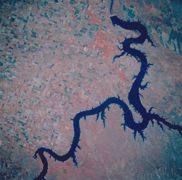 |
| STS047-109-070 Lake Oahe and Oahe Dam, South Dakota, U.S.A. September 1992 Lake Oahe and Oahe Dam, completed in 1958 and one of the largest rolled-earth dams in the United States, are featured in this infrared, south-southeast-looking, low-oblique photograph. Stretching from near Pierre, South Dakota, to just south of Bismarck, North Dakota, Lake Oahe is approximately 250 miles (402 kilometers) long. Visible to the east of the lake are numerous agricultural fields, and to the west is a rolling grassland. The name Oahe comes from the old Oahe Indian Mission that was established in 1874 a short distance from the present dam. The reservoir was constructed as part of the Missouri River Reclamation Project to provide flood control, hydroelectric power, irrigation, and recreation. |
| Images: | All Available Images Low-Resolution 347k |
|
| Mission: | STS047 |
|
| Roll - Frame: | 109 - 70 |
|
| Geographical Name: | USA-SOUTH DAKOTA |
|
| Features: | LAKE OAHE |
|
| Center Lat x Lon: | 45.5N x 100W |
|
| Film Exposure: | N | N=Normal exposure, U=Under exposed, O=Over exposed, F=out of Focus |
| Percentage of Cloud Cover-CLDP: | 0 |
|
| Camera:: | HB |
|
| Camera Tilt: | 5 | LO=Low Oblique, HO=High Oblique, NV=Near Vertical |
| Camera Focal Length: | 250 |
|
| Nadir to Photo Center Direction: | S | The direction from the nadir to the center point, N=North, S=South, E=East, W=West |
| Stereo?: | N | Y=Yes there is an adjacent picture of the same area, N=No there isn't |
| Orbit Number: | 34 |
|
| Date: | 19920914 | YYYYMMDD |
| Time: | 162246 | GMT HHMMSS |
| Nadir Lat: | 45.7N |
Latitude of suborbital point of spacecraft |
| Nadir Lon: | 100.1W |
Longitude of suborbital point of spacecraft |
| Sun Azimuth: | 135 | Clockwise angle in degrees from north to the sun measured at the nadir point |
| Space Craft Altitude: | 169 | nautical miles |
| Sun Elevation: | 39 | Angle in degrees between the horizon and the sun, measured at the nadir point |
| Land Views: | PLAIN |
|
| Water Views: | LAKE |
|
| Atmosphere Views: | |
|
| Man Made Views: | DAM, AGRICULTURE |
|
| City Views: | |
|
Photo is not associated with any sequences | ||
| NASA Home Page |
JSC Home Page |
JSC Digital Image Collection |
Earth Science & Remote Sensing |
|
This service is provided by the International Space Station program and the JSC Earth Science & Remote Sensing Unit, ARES Division, Exploration Integration Science Directorate.

|