 Photo #: STS043-84-27 Date: Aug. 1991
Geographic Region: USA-FLORIDA
Feature: ORLANDO

 Photo #: STS043-84-27 Date: Aug. 1991 Photo #: STS043-84-27 Date: Aug. 1991Geographic Region: USA-FLORIDA Feature: ORLANDO |
 |
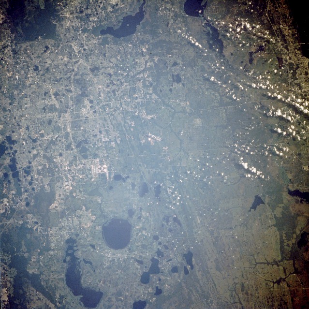
| STS043-084-027 Orlando, Florida, U.S.A. August 1991 Orlando, with an estimated population of 200 000, is spread across the northwestern quadrant of this near-vertical photograph of east-central Florida. Numerous lakes--among them, East Lake Tohopekaliga, the circular feature south of the large airport, and elongated Lake Tohopekaliga to the southwest--were formed as chemical weathering eroded the underlying limestone rocks, causing sinkholes to develop. All of central Florida is characterized by this karst topography. The north-south-oriented streaks east of East Lake Tohopekaliga are ancient beach terraces that resulted from the gradual uplift of the Florida peninsula. Two parallel highways, State Highway 50 (northern) and State Highway 528 (also known as Bee Line Expressway), connect the Orlando area with the east coast of Florida. Barely discernible on the western edge of the photograph is the Disney World complex, almost equidistant between Orlando and Kissimmee, the city at the north end of Lake Tohopekaliga. |
| Images: | All Available Images Low-Resolution 158k |
|
| Mission: | STS043 |
|
| Roll - Frame: | 84 - 27 |
|
| Geographical Name: | USA-FLORIDA |
|
| Features: | ORLANDO |
|
| Center Lat x Lon: | 28.5N x 81W |
|
| Film Exposure: | N | N=Normal exposure, U=Under exposed, O=Over exposed, F=out of Focus |
| Percentage of Cloud Cover-CLDP: | 10 |
|
| Camera:: | HB |
|
| Camera Tilt: | 14 | LO=Low Oblique, HO=High Oblique, NV=Near Vertical |
| Camera Focal Length: | 250 |
|
| Nadir to Photo Center Direction: | W | The direction from the nadir to the center point, N=North, S=South, E=East, W=West |
| Stereo?: | Y | Y=Yes there is an adjacent picture of the same area, N=No there isn't |
| Orbit Number: | 79 |
|
| Date: | 19910807 | YYYYMMDD |
| Time: | 125728 | GMT HHMMSS |
| Nadir Lat: | 28.3N |
Latitude of suborbital point of spacecraft |
| Nadir Lon: | 80.3W |
Longitude of suborbital point of spacecraft |
| Sun Azimuth: | 85 | Clockwise angle in degrees from north to the sun measured at the nadir point |
| Space Craft Altitude: | 177 | nautical miles |
| Sun Elevation: | 27 | Angle in degrees between the horizon and the sun, measured at the nadir point |
| Land Views: | PENINSULA, PLAIN |
|
| Water Views: | LAKE |
|
| Atmosphere Views: | |
|
| Man Made Views: | URBAN AREA |
|
| City Views: | |
|
Photo is not associated with any sequences | ||
| NASA Home Page |
JSC Home Page |
JSC Digital Image Collection |
Earth Science & Remote Sensing |
|
|