Geographic Region: AUSTRALIA-SA
Feature: LAKE EYRE,SIMPSON DESERT
|
Geographic Region: AUSTRALIA-SA Feature: LAKE EYRE,SIMPSON DESERT |
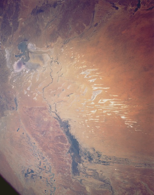 |
| STS043-151-294 Simpson Desert, South Australia, Australia August 1991 A small part of the massive interior drainage pattern that prevails throughout most of the central part of the Australian continent can be seen in this synoptic view of northeast South Australia. The general drainage through this section of the Simpson Desert is from the northeast to the southwest. Drainage in this picture can be traced from the Diamantina River which is the dark line slightly left of the top center of the image. The river enters the Goyder Lagoon (the broad, elongated dark area, upper middle). Southwest of the Goyder Lagoon, the Warburton River continues the southwesterly drainage journey to Lake Eyre (visible at bottom right). The Sturt Stony Desert appears to separate the Diamantina-Warburton drainage system from another drainage basin to the southeast. The linear, narrow, lighter colored features north of the Warburton River and Lake Eyre are numerous dry lake beds, generally oriented in a north-south alignment. |
| Images: | All Available Images Low-Resolution 83k |
|
| Mission: | STS043 |
|
| Roll - Frame: | 151 - 294 |
|
| Geographical Name: | AUSTRALIA-SA |
|
| Features: | LAKE EYRE,SIMPSON DESERT |
|
| Center Lat x Lon: | 27S x 138.5E |
|
| Film Exposure: | N | N=Normal exposure, U=Under exposed, O=Over exposed, F=out of Focus |
| Percentage of Cloud Cover-CLDP: | 0 |
|
| Camera:: | LH |
|
| Camera Tilt: | 32 | LO=Low Oblique, HO=High Oblique, NV=Near Vertical |
| Camera Focal Length: | 90 |
|
| Nadir to Photo Center Direction: | SE | The direction from the nadir to the center point, N=North, S=South, E=East, W=West |
| Stereo?: | N | Y=Yes there is an adjacent picture of the same area, N=No there isn't |
| Orbit Number: | 122 |
|
| Date: | 19910810 | YYYYMMDD |
| Time: | 063208 | GMT HHMMSS |
| Nadir Lat: | 25.7S |
Latitude of suborbital point of spacecraft |
| Nadir Lon: | 137.4E |
Longitude of suborbital point of spacecraft |
| Sun Azimuth: | 302 | Clockwise angle in degrees from north to the sun measured at the nadir point |
| Space Craft Altitude: | 164 | nautical miles |
| Sun Elevation: | 23 | Angle in degrees between the horizon and the sun, measured at the nadir point |
| Land Views: | DESERT |
|
| Water Views: | RIVER, LAKE |
|
| Atmosphere Views: | |
|
| Man Made Views: | |
|
| City Views: | |
|
Photo is not associated with any sequences | ||
| NASA Home Page |
JSC Home Page |
JSC Digital Image Collection |
Earth Science & Remote Sensing |
|
This service is provided by the International Space Station program and the JSC Earth Science & Remote Sensing Unit, ARES Division, Exploration Integration Science Directorate.

|