Geographic Region: AUSTRALIA-WA
Feature: GREAT SANDY DESERT, LAKE DORA
|
Geographic Region: AUSTRALIA-WA Feature: GREAT SANDY DESERT, LAKE DORA |
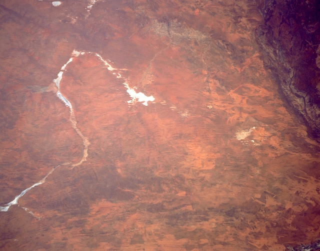 |
| STS043-151-286 Great Sandy Desert, Western Australia August 1991 The southern margin of the Great Sandy Desert where it merges with the Gibson Desert (top of image) is captured in this synoptic southerly view. The horse shoe-shaped, lighter feature (left center) is actually a series of dry lake beds that include the western tip of the Percival Lakes, Lake Auld, Lake George, Lake Winifred, Lake Blanche and Lake Dora (the largest whitish-looking dry lake near the center of the image). Even Lake Wau Karlycarly, another dry lake, is barely visible northwest of Lake Dora. Sand ridges (thin, dark paralleling lines) and fire scars (creates unusual patterns, usually lighter in color over the landscape) are visible in this flat to hilly grassland desert in north central Western Australia. Part of the Oakover River system can be identified by the braided stream pattern in the darker upper right corner of the picture. |
| Images: | All Available Images Low-Resolution 255k |
|
| Mission: | STS043 |
|
| Roll - Frame: | 151 - 286 |
|
| Geographical Name: | AUSTRALIA-WA |
|
| Features: | GREAT SANDY DESERT, LAKE DORA |
|
| Center Lat x Lon: | 22S x 123.0E |
|
| Film Exposure: | N | N=Normal exposure, U=Under exposed, O=Over exposed, F=out of Focus |
| Percentage of Cloud Cover-CLDP: | 0 |
|
| Camera:: | LH |
|
| Camera Tilt: | 8 | LO=Low Oblique, HO=High Oblique, NV=Near Vertical |
| Camera Focal Length: | 90 |
|
| Nadir to Photo Center Direction: | S | The direction from the nadir to the center point, N=North, S=South, E=East, W=West |
| Stereo?: | N | Y=Yes there is an adjacent picture of the same area, N=No there isn't |
| Orbit Number: | 122 |
|
| Date: | 19910810 | YYYYMMDD |
| Time: | 062826 | GMT HHMMSS |
| Nadir Lat: | 21.6S |
Latitude of suborbital point of spacecraft |
| Nadir Lon: | 122.9E |
Longitude of suborbital point of spacecraft |
| Sun Azimuth: | 311 | Clockwise angle in degrees from north to the sun measured at the nadir point |
| Space Craft Altitude: | 165 | nautical miles |
| Sun Elevation: | 36 | Angle in degrees between the horizon and the sun, measured at the nadir point |
| Land Views: | DESERT |
|
| Water Views: | LAKE, RIVER |
|
| Atmosphere Views: | |
|
| Man Made Views: | |
|
| City Views: | |
|
Photo is not associated with any sequences | ||
| NASA Home Page |
JSC Home Page |
JSC Digital Image Collection |
Earth Science & Remote Sensing |
|
This service is provided by the International Space Station program and the JSC Earth Science & Remote Sensing Unit, ARES Division, Exploration Integration Science Directorate.

|