Geographic Region: AUSTRALIA-Q
Feature: MACKAY,SHOALWATER BAY
|
Geographic Region: AUSTRALIA-Q Feature: MACKAY,SHOALWATER BAY |
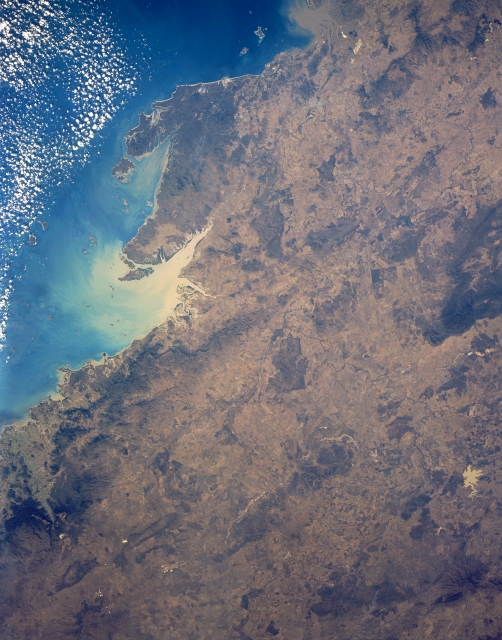 |
| STS043-151-267 Broad Sound, Queensland, Australia August 1991 The northeast coast of Queensland has a variety of bays, islands, and peninsulas that identify a unique coastline along the western boundary of the Capricorn Channel. This coastline has a variety of water discharge points where sediment has the potential to damage the Great Barrier Reef. The highly reflective water surface in Broad Sound shows a substantial quantity of sediment in this embayment. Even the sediment laden Keppel Bay (top center) suggests that the region in this synoptic view has experienced recent widespread precipitation causing the runoff into the coastal waters. The proximity of some of these discharge areas to the Great Barrier Reef that extends 1200 miles (1930 kilometers) is of environmental concern to keep the world's largest reef system healthy and from being contaminated by sediments that could adversely effect the living coral of the reefs. Shoalwater Bay is the other V-shaped bay east of Broad Sound. The irregular-shaped, lighter colored feature near the bottom right corner of the image is muddy-looking Fairbaith Reservoir which is located southwest of the small town of Emerald. The darker landscape shows areas of low mountains that include the Connors, Broadsound, and Boomer Ranges. |
| Images: | All Available Images Low-Resolution 296k |
|
| Mission: | STS043 |
|
| Roll - Frame: | 151 - 267 |
|
| Geographical Name: | AUSTRALIA-Q |
|
| Features: | MACKAY,SHOALWATER BAY |
|
| Center Lat x Lon: | 22.5S x 149.5E |
|
| Film Exposure: | N | N=Normal exposure, U=Under exposed, O=Over exposed, F=out of Focus |
| Percentage of Cloud Cover-CLDP: | 10 |
|
| Camera:: | LH |
|
| Camera Tilt: | 10 | LO=Low Oblique, HO=High Oblique, NV=Near Vertical |
| Camera Focal Length: | 90 |
|
| Nadir to Photo Center Direction: | NW | The direction from the nadir to the center point, N=North, S=South, E=East, W=West |
| Stereo?: | N | Y=Yes there is an adjacent picture of the same area, N=No there isn't |
| Orbit Number: | 121 |
|
| Date: | 19910810 | YYYYMMDD |
| Time: | 045849 | GMT HHMMSS |
| Nadir Lat: | 22.9S |
Latitude of suborbital point of spacecraft |
| Nadir Lon: | 149.8E |
Longitude of suborbital point of spacecraft |
| Sun Azimuth: | 308 | Clockwise angle in degrees from north to the sun measured at the nadir point |
| Space Craft Altitude: | 165 | nautical miles |
| Sun Elevation: | 32 | Angle in degrees between the horizon and the sun, measured at the nadir point |
| Land Views: | MOUNTAIN, COAST |
|
| Water Views: | BAY, SEDIMENT, RESERVOIR |
|
| Atmosphere Views: | |
|
| Man Made Views: | |
|
| City Views: | |
|
Photo is not associated with any sequences | ||
| NASA Home Page |
JSC Home Page |
JSC Digital Image Collection |
Earth Science & Remote Sensing |
|
This service is provided by the International Space Station program and the JSC Earth Science & Remote Sensing Unit, ARES Division, Exploration Integration Science Directorate.

|