
Geographic Region: USA-CALIFORNIA
Feature: SIERRA NEVADA, TAHOE LK.
|
Geographic Region: USA-CALIFORNIA Feature: SIERRA NEVADA, TAHOE LK. |
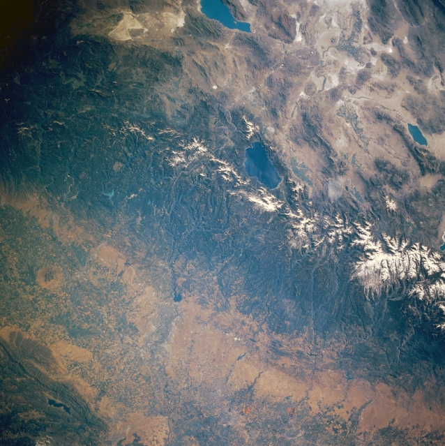 |
| STS040-609-040 Sierra Nevada Mountains and Lake Tahoe, California, U.S.A. June 1991 The Central Valley, the snowcapped Sierra Nevada Range, and Lake Tahoe are visible in this synoptic, low-oblique, east-looking photograph. The Central Valley's numerous agricultural fields trend north-south. Sacramento and Stockton (near the bottom center of the photograph) are visible. The forested Sierra Nevada Mountains trend north-northwest-south-southeast. The forested areas are part of the Tahoe, El Dorado, and Stanislaus National Forests. Centrally located is Lake Tahoe, a large depression-filled lake within the Sierra Nevadas. Viewing clockwise from Pyramid Lake at the top center of the photograph are Walker Lake and part of Mono Lake. |
| Images: | All Available Images Low-Resolution 381k |
|
| Mission: | STS040 |
|
| Roll - Frame: | 609 - 40 |
|
| Geographical Name: | USA-CALIFORNIA |
|
| Features: | SIERRA NEVADA, TAHOE LK. |
|
| Center Lat x Lon: | 39.0N x 120W |
|
| Film Exposure: | N | N=Normal exposure, U=Under exposed, O=Over exposed, F=out of Focus |
| Percentage of Cloud Cover-CLDP: | 0 |
|
| Camera:: | RX |
|
| Camera Tilt: | LO | LO=Low Oblique, HO=High Oblique, NV=Near Vertical |
| Camera Focal Length: | 100 |
|
| Nadir to Photo Center Direction: | The direction from the nadir to the center point, N=North, S=South, E=East, W=West |
|
| Stereo?: | N | Y=Yes there is an adjacent picture of the same area, N=No there isn't |
| Orbit Number: | |
|
| Date: | 199106__ | YYYYMMDD |
| Time: | GMT HHMMSS |
|
| Nadir Lat: | N |
Latitude of suborbital point of spacecraft |
| Nadir Lon: | E |
Longitude of suborbital point of spacecraft |
| Sun Azimuth: | Clockwise angle in degrees from north to the sun measured at the nadir point |
|
| Space Craft Altitude: | nautical miles |
|
| Sun Elevation: | Angle in degrees between the horizon and the sun, measured at the nadir point |
|
| Land Views: | MOUNTAIN, FAULT, VALLEY, BASIN |
|
| Water Views: | LAKE |
|
| Atmosphere Views: | |
|
| Man Made Views: | AGRICULTURE |
|
| City Views: | |
|
Photo is not associated with any sequences | ||
| NASA Home Page |
JSC Home Page |
JSC Digital Image Collection |
Earth Science & Remote Sensing |
|
This service is provided by the International Space Station program and the JSC Earth Science & Remote Sensing Unit, ARES Division, Exploration Integration Science Directorate.

|