
Geographic Region: USA-TEXAS
Feature: GUADALUPE MTNS AREA
|
Geographic Region: USA-TEXAS Feature: GUADALUPE MTNS AREA |
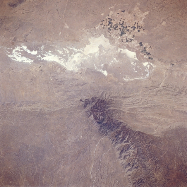 |
| STS039-096-069 Guadalupe Mountains, Texas, U.S.A. May 1991 Featured in this photograph are Salt Basin, a broad, flat valley consisting of windblown sands and white alkali salt flats approximately 70 miles (113 kilometers) due east of El Paso, and the dark, rugged Guadalupe Mountains, the largest fossil reef in the world. El Capitan, an imposing cliff composed of limestone reef rock, and Guadalupe Peak [8749 feet (2667 meters) above sea level], the highest point in Texas, are near the southern end of the Guadalupe Mountains. Combined U.S. Highway 62 and U.S. Highway 180, the linear east-west-trending feature, can be traced across this arid landscape, just south of an agricultural area. Irrigated field patterns west of the salt flats identify the small town of Dell City. |
| Images: | All Available Images Low-Resolution 313k |
|
| Mission: | STS039 |
|
| Roll - Frame: | 96 - 69 |
|
| Geographical Name: | USA-TEXAS |
|
| Features: | GUADALUPE MTNS AREA |
|
| Center Lat x Lon: | 31.8N x 104.9W |
|
| Film Exposure: | N | N=Normal exposure, U=Under exposed, O=Over exposed, F=out of Focus |
| Percentage of Cloud Cover-CLDP: | 0 |
|
| Camera:: | HB |
|
| Camera Tilt: | 27 | LO=Low Oblique, HO=High Oblique, NV=Near Vertical |
| Camera Focal Length: | 250 |
|
| Nadir to Photo Center Direction: | W | The direction from the nadir to the center point, N=North, S=South, E=East, W=West |
| Stereo?: | N | Y=Yes there is an adjacent picture of the same area, N=No there isn't |
| Orbit Number: | 72 |
|
| Date: | 19910502 | YYYYMMDD |
| Time: | 203234 | GMT HHMMSS |
| Nadir Lat: | 32.2N |
Latitude of suborbital point of spacecraft |
| Nadir Lon: | 103.8W |
Longitude of suborbital point of spacecraft |
| Sun Azimuth: | 202 | Clockwise angle in degrees from north to the sun measured at the nadir point |
| Space Craft Altitude: | 138 | nautical miles |
| Sun Elevation: | 60 | Angle in degrees between the horizon and the sun, measured at the nadir point |
| Land Views: | MOUNTAIN, DESERT, BASIN |
|
| Water Views: | PLAYA |
|
| Atmosphere Views: | |
|
| Man Made Views: | AGRICULTURE |
|
| City Views: | |
|
Photo is not associated with any sequences | ||
| NASA Home Page |
JSC Home Page |
JSC Digital Image Collection |
Earth Science & Remote Sensing |
|
This service is provided by the International Space Station program and the JSC Earth Science & Remote Sensing Unit, ARES Division, Exploration Integration Science Directorate.

|