
Geographic Region: USA-TEXAS
Feature: ARLINGTON, LOVE FIELD
|
Geographic Region: USA-TEXAS Feature: ARLINGTON, LOVE FIELD |
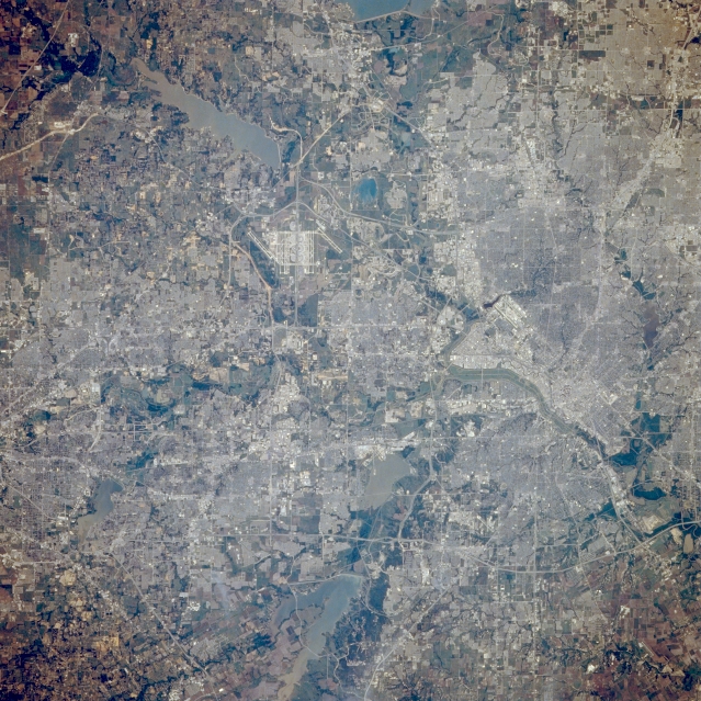 |
| STS039-085-032 Dallas-Fort Worth Metroplex, Texas, U.S.A. May 1991 Featured in this photograph are a large section of metropolitan Dallas; most of the eastern half of Fort Worth; and the connecting land corridor between these two dynamic north Texas cities, including Irving, Grand Prairie, and Arlington, where phenomenal growth has occurred during the last half of the 20th century. The runways of Dallas-Fort Worth International Airport are visible slightly north of center, and Dallas Love Field appears northwest of the central business district of Dallas. Viewing from north to south are several large reservoirs--Garza Little Elm Reservoir (southern end and dam), Grapevine Lake, North Lake (smaller, darker lake northeast of Dallas-Fort Worth International Airport), Mountain Creek Lake, and Joe Pool Lake. Visible are the general drainage features through the urban area and many highways, roads, and streets creating a checkerboard pattern. In this partial view of Dallas and Ft. Worth, Texas, USA (33.0N, 97.0W) the detail is good enough to use as a road map of the major highways throughout the area. The new Dallas/Ft. Worth International Airport is near the center of the scene. Almost twenty lakes and reservoirs in the area, reflecting the recent heavy spring rainfall, by their high water levels, are easily delineated in the view. |
| Images: | All Available Images Low-Resolution 403k |
|
| Mission: | STS039 |
|
| Roll - Frame: | 85 - 32 |
|
| Geographical Name: | USA-TEXAS |
|
| Features: | ARLINGTON, LOVE FIELD |
|
| Center Lat x Lon: | 32.8N x 96.9W |
|
| Film Exposure: | N | N=Normal exposure, U=Under exposed, O=Over exposed, F=out of Focus |
| Percentage of Cloud Cover-CLDP: | 0 |
|
| Camera:: | HB |
|
| Camera Tilt: | 17 | LO=Low Oblique, HO=High Oblique, NV=Near Vertical |
| Camera Focal Length: | 250 |
|
| Nadir to Photo Center Direction: | SE | The direction from the nadir to the center point, N=North, S=South, E=East, W=West |
| Stereo?: | Y | Y=Yes there is an adjacent picture of the same area, N=No there isn't |
| Orbit Number: | 40 |
|
| Date: | 19910430 | YYYYMMDD |
| Time: | 204829 | GMT HHMMSS |
| Nadir Lat: | 33.3N |
Latitude of suborbital point of spacecraft |
| Nadir Lon: | 97.4W |
Longitude of suborbital point of spacecraft |
| Sun Azimuth: | 243 | Clockwise angle in degrees from north to the sun measured at the nadir point |
| Space Craft Altitude: | 139 | nautical miles |
| Sun Elevation: | 53 | Angle in degrees between the horizon and the sun, measured at the nadir point |
| Land Views: | PLAIN, RANGE |
|
| Water Views: | RESERVOIR, LAKE |
|
| Atmosphere Views: | |
|
| Man Made Views: | AIRPORT, DAM, HIGHWAY, URBAN AREA |
|
| City Views: | |
|
Photo is not associated with any sequences | ||
| NASA Home Page |
JSC Home Page |
JSC Digital Image Collection |
Earth Science & Remote Sensing |
|
This service is provided by the International Space Station program and the JSC Earth Science & Remote Sensing Unit, ARES Division, Exploration Integration Science Directorate.

|