 Photo #: STS039-151-7 Date: Apr. 1991
Geographic Region: RUSSIAN FEDERATION
Feature: VOLGA RIVER DELTA

 Photo #: STS039-151-7 Date: Apr. 1991 Photo #: STS039-151-7 Date: Apr. 1991Geographic Region: RUSSIAN FEDERATION Feature: VOLGA RIVER DELTA |
 |
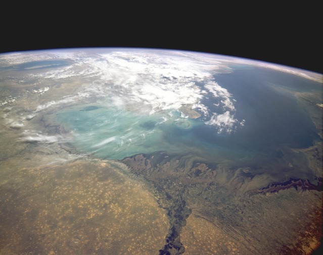
| STS039-151-007 Volga River Delta and Caspian Sea, Kazakhstan and Russia May 1991 The broad, fan-shaped delta of the Volga River and the largest inland body of water in the world, the Caspian Sea, are the centerpieces of this high-oblique, south-looking photograph. The Volga River Delta, an important wetland region, is over 124 miles (200 kilometers) wide and enters the Caspian Sea below sea level. The city of Astrakhan is visible as a grayish-blue smudge west of the river near the apex of the delta. Though located in an arid area, the delta supports more than 250 species of birds, 60 species of mammals, and 80 species of plants. A rich fish fauna exists, which includes 25 percent of the world's sturgeon species-a great source of the world's supply of caviar. The Caspian Sea, 92 feet (30 meters) below sea level, is approximately 745 miles (1200 kilometers) long and 270 miles (440 kilometers) wide. The Volga supplies approximately 75 percent of the water inflow to the sea, which has no outflow. Caspian Sea water levels have been dropping since the early 1960s due mostly to the construction of large dams and reservoirs on the Volga River. Plans are under way to alleviate this problem by diverting water from some rivers in central Siberia to the Caspian Sea, but no timetable has been established by the Russian Government. Most of the patterned areas in the southern Ryn Desert north of the Caspian Sea are wells of some type. The Aral Sea is visible near the horizon east of the Caspian Sea. |
| Images: | All Available Images Low-Resolution 73k |
|
| Mission: | STS039 |
|
| Roll - Frame: | 151 - 7 |
|
| Geographical Name: | RUSSIAN FEDERATION |
|
| Features: | VOLGA RIVER DELTA |
|
| Center Lat x Lon: | 45.5N x 49.0E |
|
| Film Exposure: | N | N=Normal exposure, U=Under exposed, O=Over exposed, F=out of Focus |
| Percentage of Cloud Cover-CLDP: | 15 |
|
| Camera:: | LH |
|
| Camera Tilt: | LO | LO=Low Oblique, HO=High Oblique, NV=Near Vertical |
| Camera Focal Length: | 90 |
|
| Nadir to Photo Center Direction: | SE | The direction from the nadir to the center point, N=North, S=South, E=East, W=West |
| Stereo?: | N | Y=Yes there is an adjacent picture of the same area, N=No there isn't |
| Orbit Number: | 17 |
|
| Date: | 19910429 | YYYYMMDD |
| Time: | 102305 | GMT HHMMSS |
| Nadir Lat: | 48.1N |
Latitude of suborbital point of spacecraft |
| Nadir Lon: | 46.3E |
Longitude of suborbital point of spacecraft |
| Sun Azimuth: | 216 | Clockwise angle in degrees from north to the sun measured at the nadir point |
| Space Craft Altitude: | 143 | nautical miles |
| Sun Elevation: | 51 | Angle in degrees between the horizon and the sun, measured at the nadir point |
| Land Views: | PLAIN |
|
| Water Views: | RIVER, DELTA, CHANNEL, SEA |
|
| Atmosphere Views: | |
|
| Man Made Views: | |
|
| City Views: | |
|
Photo is not associated with any sequences | ||
| NASA Home Page |
JSC Home Page |
JSC Digital Image Collection |
Earth Science & Remote Sensing |
|
|