 Photo #: STS038-74-86 Date: Nov. 1990
Geographic Region: LOYALTY ISLANDS
Feature: OUVEA ATOLL,BEAUTEMPS I.

 Photo #: STS038-74-86 Date: Nov. 1990 Photo #: STS038-74-86 Date: Nov. 1990Geographic Region: LOYALTY ISLANDS Feature: OUVEA ATOLL,BEAUTEMPS I. |
 |
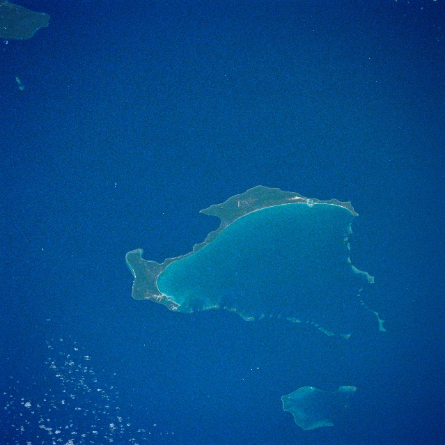
| STS038-74-86 Ouvea Island, Beautemps Atoll, Loyality Islands November 1990 This southeast-looking view shows the beautiful light blue waters surrounding Ouvea Island. Ouvea Island is a coral atoll that rests on the remains of a submerged volcanic island. The coral atoll was uplifted millions of years ago giving birth to the slightly raised land mass now visible on the image. Only the southeast portion of the present island was uplifted, thus the overall island retains its original appearance particularly the island's large lagoon. The 16 miles (25 km) of white sandy beach facing the lagoon is considered to be one of the most beautiful beaches in the world. There are no rivers on Ouvea Island. The water, which supplies the people who live on the island, comes from rain that seeps through the calcareous soil and forms freshwater pools. Ouvea Island is approximately 62 miles (100 km) northeast of New Caledonia. Beautemps Atoll is visible near the lower right of the image. Jovan Reef is discernible in the upper left portion of the image. |
| Images: | All Available Images Low-Resolution 345k |
|
| Mission: | STS038 |
|
| Roll - Frame: | 74 - 86 |
|
| Geographical Name: | LOYALTY ISLANDS |
|
| Features: | OUVEA ATOLL,BEAUTEMPS I. |
|
| Center Lat x Lon: | 20.6S x 166.6E |
|
| Film Exposure: | N | N=Normal exposure, U=Under exposed, O=Over exposed, F=out of Focus |
| Percentage of Cloud Cover-CLDP: | 10 |
|
| Camera:: | HB |
|
| Camera Tilt: | 42 | LO=Low Oblique, HO=High Oblique, NV=Near Vertical |
| Camera Focal Length: | 250 |
|
| Nadir to Photo Center Direction: | NW | The direction from the nadir to the center point, N=North, S=South, E=East, W=West |
| Stereo?: | N | Y=Yes there is an adjacent picture of the same area, N=No there isn't |
| Orbit Number: | 15 |
|
| Date: | 19901116 | YYYYMMDD |
| Time: | 214014 | GMT HHMMSS |
| Nadir Lat: | 22.1S |
Latitude of suborbital point of spacecraft |
| Nadir Lon: | 168.1E |
Longitude of suborbital point of spacecraft |
| Sun Azimuth: | 94 | Clockwise angle in degrees from north to the sun measured at the nadir point |
| Space Craft Altitude: | 142 | nautical miles |
| Sun Elevation: | 50 | Angle in degrees between the horizon and the sun, measured at the nadir point |
| Land Views: | ISLAND, ATOLL |
|
| Water Views: | REEF, LAGOON |
|
| Atmosphere Views: | |
|
| Man Made Views: | |
|
| City Views: | |
|
Photo is not associated with any sequences | ||
| NASA Home Page |
JSC Home Page |
JSC Digital Image Collection |
Earth Science & Remote Sensing |
|
|