
Geographic Region: USA-WASHINGTON
Feature: PUGET SND,SEATTLE,TACOMA
|
Geographic Region: USA-WASHINGTON Feature: PUGET SND,SEATTLE,TACOMA |
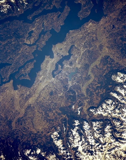 |
| STS036-152-013 Seattle and Puget Sound, Washington, U.S.A. March 1990 Puget Sound and the Seattle area, flanked to the east by the snow-covered Cascade Range, are presented in this northwest-looking, low-oblique photograph. Built on seven hills between Puget Sound's Elliot Bay and dark blue Lake Washington, Seattle lies in an earthquake-prone area. The city, the largest in the Pacific Northwest, is the region's commercial, cultural, and transportation hub. It is a center for aircraft manufacturing and shipbuilding; other industries include food processing, electronics, computer software, lumber, chemicals, metal goods, machinery, textiles and apparel, and tourism. A major port of entry with excellent natural harbors, Seattle is important to Alaskan and Far Eastern trade. Small, turquoise Lake Sammamish lies east of Lake Washington. Interstate Highway 5 traverses from the north (through Everett, near the upper right) to the south (through Tacoma, midway between the bottom left and bottom center). Interstate Highway 90 crosses central Seattle and Lake Washington to the east and progresses south of Lake Sammamish into the snow-covered Cascades. Puget Sound, an arm of the Pacific Ocean connected with the Pacific by the Strait of Juan de Fuca, lies west of Seattle. The sound is more than 100 miles (160 kilometers) long, has numerous islands, and can be navigated by large ships. |
| Images: | All Available Images Low-Resolution 158k |
|
| Mission: | STS036 |
|
| Roll - Frame: | 152 - 13 |
|
| Geographical Name: | USA-WASHINGTON |
|
| Features: | PUGET SND,SEATTLE,TACOMA |
|
| Center Lat x Lon: | 47.5N x 122W |
|
| Film Exposure: | N | N=Normal exposure, U=Under exposed, O=Over exposed, F=out of Focus |
| Percentage of Cloud Cover-CLDP: | 0 |
|
| Camera:: | LH |
|
| Camera Tilt: | 16 | LO=Low Oblique, HO=High Oblique, NV=Near Vertical |
| Camera Focal Length: | 250 |
|
| Nadir to Photo Center Direction: | W | The direction from the nadir to the center point, N=North, S=South, E=East, W=West |
| Stereo?: | Y | Y=Yes there is an adjacent picture of the same area, N=No there isn't |
| Orbit Number: | 40 |
|
| Date: | 19900302 | YYYYMMDD |
| Time: | 182045 | GMT HHMMSS |
| Nadir Lat: | 47.6N |
Latitude of suborbital point of spacecraft |
| Nadir Lon: | 121.4W |
Longitude of suborbital point of spacecraft |
| Sun Azimuth: | 146 | Clockwise angle in degrees from north to the sun measured at the nadir point |
| Space Craft Altitude: | 125 | nautical miles |
| Sun Elevation: | 30 | Angle in degrees between the horizon and the sun, measured at the nadir point |
| Land Views: | |
|
| Water Views: | |
|
| Atmosphere Views: | |
|
| Man Made Views: | URBAN AREA |
|
| City Views: | SEATTLE |
|
Photo is not associated with any sequences | ||
| NASA Home Page |
JSC Home Page |
JSC Digital Image Collection |
Earth Science & Remote Sensing |
|
This service is provided by the International Space Station program and the JSC Earth Science & Remote Sensing Unit, ARES Division, Exploration Integration Science Directorate.

|