
Geographic Region: USA-IOWA
Feature: L. RATHBURN,L. RED ROCK,AG
|
Geographic Region: USA-IOWA Feature: L. RATHBURN,L. RED ROCK,AG |
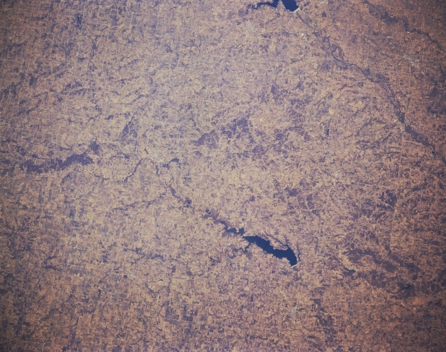 |
| STS036-152-113 South-Central Iowa, U.S.A. March 1990 The gently rolling agricultural lands of south-central Iowa are visible in this north-northwest-looking, low-oblique photograph. Discernible are two bodies of water--dark blue Lake Rathbun, which supplies some irrigation but is primarily a recreational area for the surrounding communities, and the southeastern portion of Red Rock Reservoir (near top center), a recreational facility on the Des Moines River. |
| Images: | All Available Images Low-Resolution 316k |
|
| Mission: | STS036 |
|
| Roll - Frame: | 152 - 113 |
|
| Geographical Name: | USA-IOWA |
|
| Features: | L. RATHBURN,L. RED ROCK,AG |
|
| Center Lat x Lon: | 41.0N x 93W |
|
| Film Exposure: | N | N=Normal exposure, U=Under exposed, O=Over exposed, F=out of Focus |
| Percentage of Cloud Cover-CLDP: | 0 |
|
| Camera:: | LH |
|
| Camera Tilt: | 9 | LO=Low Oblique, HO=High Oblique, NV=Near Vertical |
| Camera Focal Length: | 250 |
|
| Nadir to Photo Center Direction: | N | The direction from the nadir to the center point, N=North, S=South, E=East, W=West |
| Stereo?: | N | Y=Yes there is an adjacent picture of the same area, N=No there isn't |
| Orbit Number: | 55 |
|
| Date: | 19900303 | YYYYMMDD |
| Time: | 164122 | GMT HHMMSS |
| Nadir Lat: | 40.7N |
Latitude of suborbital point of spacecraft |
| Nadir Lon: | 92.9W |
Longitude of suborbital point of spacecraft |
| Sun Azimuth: | 147 | Clockwise angle in degrees from north to the sun measured at the nadir point |
| Space Craft Altitude: | 115 | nautical miles |
| Sun Elevation: | 37 | Angle in degrees between the horizon and the sun, measured at the nadir point |
| Land Views: | PLAIN |
|
| Water Views: | LAKE |
|
| Atmosphere Views: | |
|
| Man Made Views: | AGRICULTURE, DAM |
|
| City Views: | |
|
Photo is not associated with any sequences | ||
| NASA Home Page |
JSC Home Page |
JSC Digital Image Collection |
Earth Science & Remote Sensing |
|
This service is provided by the International Space Station program and the JSC Earth Science & Remote Sensing Unit, ARES Division, Exploration Integration Science Directorate.

|