Geographic Region: ATLANTIC OCEAN I(S).
Feature: ASCENSION I,CEN OF FRAME
|
Geographic Region: ATLANTIC OCEAN I(S). Feature: ASCENSION I,CEN OF FRAME |
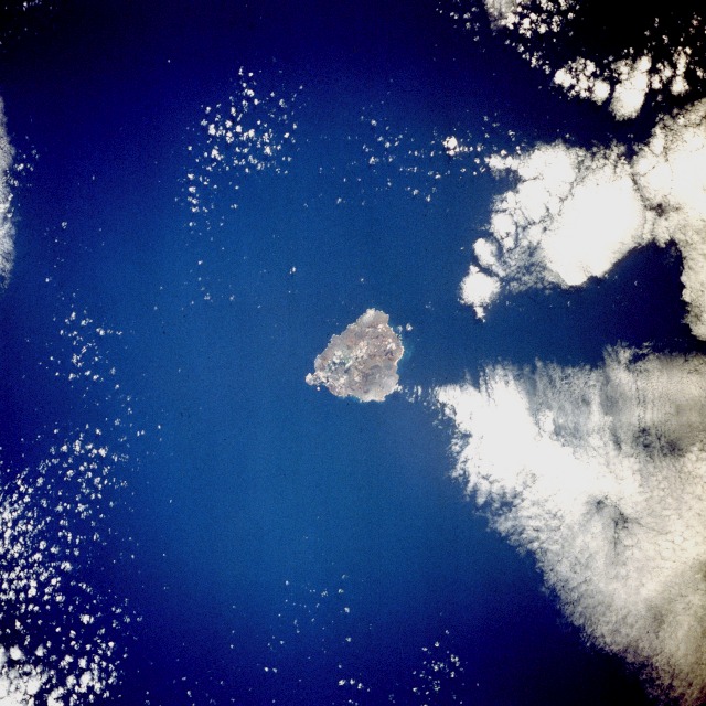 |
| STS035-081-103 Ascension Island, Atlantic Ocean December 1990 Located in the middle of the south Atlantic Ocean, Ascension Island (latitude 8 degrees south) is one of the few surface manifestations of the Mid-Atlantic Ridge. A British possession populated by fewer than 1000, this small volcanic island measures approximately 9 miles (14 kilometers) in length and 6 miles (10 kilometers) in width. The highest point on the island, Green Mountain, which reaches 2817 feet (860 meters) above sea level, is an extinct volcanic crater located near the southeast coast. Georgetown, the only settlement, is on the west side of the island. Ascension was discovered by Portuguese navigator Joao da Nova on Ascension Day 1501, thereby providing the island its name. American engineers constructed an airfield on the island's southwest side during World War II, and the facility was used as a refueling base for selected transatlantic flights. |
| Images: | All Available Images Low-Resolution 137k |
|
| Mission: | STS035 |
|
| Roll - Frame: | 81 - 103 |
|
| Geographical Name: | ATLANTIC OCEAN I(S). |
|
| Features: | ASCENSION I,CEN OF FRAME |
|
| Center Lat x Lon: | 8S x 14.4W |
|
| Film Exposure: | N | N=Normal exposure, U=Under exposed, O=Over exposed, F=out of Focus |
| Percentage of Cloud Cover-CLDP: | 30 |
|
| Camera:: | HB |
|
| Camera Tilt: | 30 | LO=Low Oblique, HO=High Oblique, NV=Near Vertical |
| Camera Focal Length: | 250 |
|
| Nadir to Photo Center Direction: | SE | The direction from the nadir to the center point, N=North, S=South, E=East, W=West |
| Stereo?: | N | Y=Yes there is an adjacent picture of the same area, N=No there isn't |
| Orbit Number: | 101 |
|
| Date: | 19901208 | YYYYMMDD |
| Time: | 161803 | GMT HHMMSS |
| Nadir Lat: | 6.8S |
Latitude of suborbital point of spacecraft |
| Nadir Lon: | 15.7W |
Longitude of suborbital point of spacecraft |
| Sun Azimuth: | 246 | Clockwise angle in degrees from north to the sun measured at the nadir point |
| Space Craft Altitude: | 184 | nautical miles |
| Sun Elevation: | 38 | Angle in degrees between the horizon and the sun, measured at the nadir point |
| Land Views: | ISLAND, VOLCANO |
|
| Water Views: | OCEAN |
|
| Atmosphere Views: | |
|
| Man Made Views: | |
|
| City Views: | |
|
Photo is not associated with any sequences | ||
| NASA Home Page |
JSC Home Page |
JSC Digital Image Collection |
Earth Science & Remote Sensing |
|
This service is provided by the International Space Station program and the JSC Earth Science & Remote Sensing Unit, ARES Division, Exploration Integration Science Directorate.

|