Geographic Region: JAPAN
Feature: SHIKOKU, HONSHU
|
Geographic Region: JAPAN Feature: SHIKOKU, HONSHU |
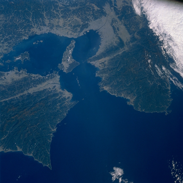 |
| STS034-083-030 Inland Sea, Japan October 1989 The Kii Channel seen in this north-looking view (center of the image) is the eastern entrance to the Inland Sea of Japan (located between southwest Honshu and Shikoku Island). Two extensive, heavily forested, mountainous landscapes flank the Kii Channel (Kii Peninsula is eastern peninsula). The Kii Fault can be traced diagonally (east-west orientation) across the image as a light-colored linear swath of various widths. The lighter-colored terrain throughout the entire image shows the distribution of human development either for urban settlements or, to a lesser degree, limited agricultural development. The greatest concentration of human activity is in the Kobe/Osaka Metroplex along the northeast end of Osaka Bay (northeast end of the Inland Sea). The Inland Sea is a large trough that includes a series of faulted depressions that are associated with some submergence, flooded by the sea, and dotted with many islands, which are the rims of the troughs. In terms of seismic activity, this region is located on the southeastern margin of the Eurasian Plate (where the Philippine Sea Plate is being subducted beneath the Eurasian Plate) and which is subject to numerous earthquakes. The Onaruto Bridge (linear, light-colored feature) is visible as it connects the northeastern tip of Shikoku Island with Awaji Island (large island near center of image). An area of dense clouds obscures the terrain in the eastern corner (upper right) of the image. |
| Images: | All Available Images Low-Resolution 305k |
|
| Mission: | STS034 |
|
| Roll - Frame: | 83 - 30 |
|
| Geographical Name: | JAPAN |
|
| Features: | SHIKOKU, HONSHU |
|
| Center Lat x Lon: | 34.0N x 135.0E |
|
| Film Exposure: | N | N=Normal exposure, U=Under exposed, O=Over exposed, F=out of Focus |
| Percentage of Cloud Cover-CLDP: | 10 |
|
| Camera:: | HB |
|
| Camera Tilt: | NV | LO=Low Oblique, HO=High Oblique, NV=Near Vertical |
| Camera Focal Length: | 100 |
|
| Nadir to Photo Center Direction: | NE | The direction from the nadir to the center point, N=North, S=South, E=East, W=West |
| Stereo?: | Y | Y=Yes there is an adjacent picture of the same area, N=No there isn't |
| Orbit Number: | 39 |
|
| Date: | 19891021 | YYYYMMDD |
| Time: | 022651 | GMT HHMMSS |
| Nadir Lat: | 32.4N |
Latitude of suborbital point of spacecraft |
| Nadir Lon: | 133.6E |
Longitude of suborbital point of spacecraft |
| Sun Azimuth: | 171 | Clockwise angle in degrees from north to the sun measured at the nadir point |
| Space Craft Altitude: | 178 | nautical miles |
| Sun Elevation: | 46 | Angle in degrees between the horizon and the sun, measured at the nadir point |
| Land Views: | FAULT, FOREST, MOUNTAIN |
|
| Water Views: | CHANNEL, SEA |
|
| Atmosphere Views: | |
|
| Man Made Views: | |
|
| City Views: | |
|
Photo is not associated with any sequences | ||
| NASA Home Page |
JSC Home Page |
JSC Digital Image Collection |
Earth Science & Remote Sensing |
|
This service is provided by the International Space Station program and the JSC Earth Science & Remote Sensing Unit, ARES Division, Exploration Integration Science Directorate.

|