
Geographic Region: USA-NEVADA
Feature: LAS VEGAS
|
Geographic Region: USA-NEVADA Feature: LAS VEGAS |
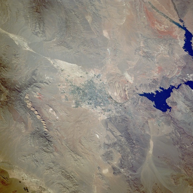 |
| STS034-072-050 Las Vegas, Nevada, U.S.A. October 1989 The city of Las Vegas, which sits in a basin, is visible in the center of this low-oblique, north-looking photograph. The drainage into this basin can be identified northwest of the city (whitish area between two mountain ranges). During occasional heavy rainfall, downtown streets flood--especially the street know as the "Strip," where most of the large hotels and gambling casinos are located. Las Vegas is famous worldwide as a tourist and recreation area and has expanded greatly in the last few decades with the growth of tourism. New residential areas appear west and northwest of the city as expansion continues. The dark blue waters of Lake Mead, one of the largest reservoirs in the United States, are seen east of Las Vegas. Hoover Dam, a white dot at the southern end of the lake, shows where the Colorado River continues its southward flow toward the Gulf of California. Between Lake Mead and Las Vegas are parallel ridges (reddish-white) formed by the tilted sedimentary rock layers of Frenchman Mountain. Visible are the reddish mountains of Red Rock Canyon west of the city and the dark, forested Spring Mountains to the northwest. |
| Images: | All Available Images Low-Resolution 135k |
|
| Mission: | STS034 |
|
| Roll - Frame: | 72 - 50 |
|
| Geographical Name: | USA-NEVADA |
|
| Features: | LAS VEGAS |
|
| Center Lat x Lon: | 36.0N x 115W |
|
| Film Exposure: | N | N=Normal exposure, U=Under exposed, O=Over exposed, F=out of Focus |
| Percentage of Cloud Cover-CLDP: | 0 |
|
| Camera:: | HB |
|
| Camera Tilt: | LO | LO=Low Oblique, HO=High Oblique, NV=Near Vertical |
| Camera Focal Length: | 250 |
|
| Nadir to Photo Center Direction: | The direction from the nadir to the center point, N=North, S=South, E=East, W=West |
|
| Stereo?: | N | Y=Yes there is an adjacent picture of the same area, N=No there isn't |
| Orbit Number: | |
|
| Date: | 198910__ | YYYYMMDD |
| Time: | GMT HHMMSS |
|
| Nadir Lat: | N |
Latitude of suborbital point of spacecraft |
| Nadir Lon: | E |
Longitude of suborbital point of spacecraft |
| Sun Azimuth: | Clockwise angle in degrees from north to the sun measured at the nadir point |
|
| Space Craft Altitude: | nautical miles |
|
| Sun Elevation: | Angle in degrees between the horizon and the sun, measured at the nadir point |
|
| Land Views: | DESERT, MOUNTAIN |
|
| Water Views: | LAKE |
|
| Atmosphere Views: | |
|
| Man Made Views: | URBAN AREA, AIRPORT |
|
| City Views: | LAS VEGAS |
|
Photo is not associated with any sequences | ||
| NASA Home Page |
JSC Home Page |
JSC Digital Image Collection |
Earth Science & Remote Sensing |
|
This service is provided by the International Space Station program and the JSC Earth Science & Remote Sensing Unit, ARES Division, Exploration Integration Science Directorate.

|