Geographic Region: AUSTRALIA-WA
Feature: LAKE MACKAY
|
Geographic Region: AUSTRALIA-WA Feature: LAKE MACKAY |
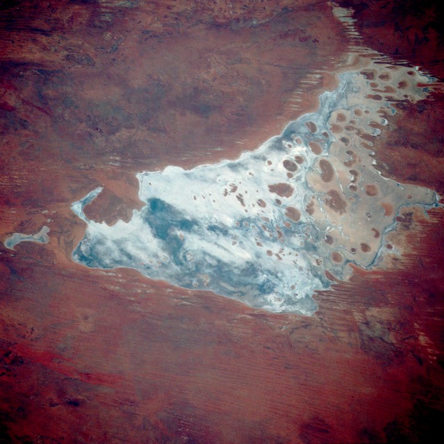 |
| STS033-073-097 Lake Mackay, Western Australia, Australia November 1989 Lake Mackay is one of hundreds of dry lakebeds scattered throughout Western Australia and the Northern Territory. The photograph documents the appearance of the dry parts of Western Australia's Great Sandy Desert, Gibson Desert, and Tanami Desert. Lake Mackay measures approximately 60 miles (100 kilometers) east-west and north-south. The darker areas of the lakebed are indicative of some form of desert vegetation or algae, some moisture within the soils of the dry lake, and the lowest elevations where pooling of water occurs. In this arid environment, salts and other minerals are carried to the surface through capillary action caused by evaporation, thereby producing the white reflective surface. Visible are various brown hills scattered across the eastern half of the lake and east-west-oriented sand ridges south of the lake. |
| Images: | All Available Images Low-Resolution 124k |
|
| Mission: | STS033 |
|
| Roll - Frame: | 73 - 97 |
|
| Geographical Name: | AUSTRALIA-WA |
|
| Features: | LAKE MACKAY |
|
| Center Lat x Lon: | 22.5S x 128.5E |
|
| Film Exposure: | N | N=Normal exposure, U=Under exposed, O=Over exposed, F=out of Focus |
| Percentage of Cloud Cover-CLDP: | 0 |
|
| Camera:: | HB |
|
| Camera Tilt: | 28 | LO=Low Oblique, HO=High Oblique, NV=Near Vertical |
| Camera Focal Length: | 250 |
|
| Nadir to Photo Center Direction: | N | The direction from the nadir to the center point, N=North, S=South, E=East, W=West |
| Stereo?: | N | Y=Yes there is an adjacent picture of the same area, N=No there isn't |
| Orbit Number: | 16 |
|
| Date: | 19891124 | YYYYMMDD |
| Time: | 001527 | GMT HHMMSS |
| Nadir Lat: | 24.7S |
Latitude of suborbital point of spacecraft |
| Nadir Lon: | 128.1E |
Longitude of suborbital point of spacecraft |
| Sun Azimuth: | 94 | Clockwise angle in degrees from north to the sun measured at the nadir point |
| Space Craft Altitude: | 251 | nautical miles |
| Sun Elevation: | 49 | Angle in degrees between the horizon and the sun, measured at the nadir point |
| Land Views: | DESERT |
|
| Water Views: | LAKE, PLAYA |
|
| Atmosphere Views: | |
|
| Man Made Views: | |
|
| City Views: | |
|
Photo is not associated with any sequences | ||
| NASA Home Page |
JSC Home Page |
JSC Digital Image Collection |
Earth Science & Remote Sensing |
|
This service is provided by the International Space Station program and the JSC Earth Science & Remote Sensing Unit, ARES Division, Exploration Integration Science Directorate.

|