Geographic Region: INDONESIA
Feature: SUNGAI RIVER DELTA
|
Geographic Region: INDONESIA Feature: SUNGAI RIVER DELTA |
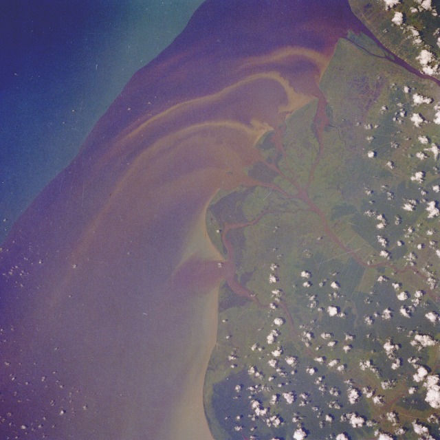 |
| STS033-71-52 Kalimantan Barat Province, Indonesia November 1989 The Government of Indonesia provides financial incentives for its citizens to emigrate from the main island of Java and establish settlements on many of Indonesia's 13 000 other islands. This photograph of a dark plume adjacent to the coastline of western Kalimantan Barat Province on Borneo provides a glimpse of how the redistribution of the population is affecting a small section of the west coast of the province. The equatorial town of Pontianak is barely discernible along the banks of the Landak River in the northeast corner of the photograph. The shore current of this part of the South China Sea is carrying southward the plume material of the westward flowing, multichanneled Kapuas River. Sediment streamers intermingle with the darker plume. The dark color of the water entering the sea is caused by tannic acid in the river water from the massive, decomposing plant material in the soils of the drainage area. The variety of sources of the sediment gives this plume its color, ranging from beach erosion to land run-off erosion. Further west is a definite plume boundary with the blue waters of the South China Sea. The light green, deforested coastline is distinguishable from the darker, undisturbed inland patches of dense rain forest. |
| Images: | All Available Images Low-Resolution 107k |
|
| Mission: | STS033 |
|
| Roll - Frame: | 71 - 52 |
|
| Geographical Name: | INDONESIA |
|
| Features: | SUNGAI RIVER DELTA |
|
| Center Lat x Lon: | 0.5S x 109.0E |
|
| Film Exposure: | N | N=Normal exposure, U=Under exposed, O=Over exposed, F=out of Focus |
| Percentage of Cloud Cover-CLDP: | 20 |
|
| Camera:: | HB |
|
| Camera Tilt: | 15 | LO=Low Oblique, HO=High Oblique, NV=Near Vertical |
| Camera Focal Length: | 250 |
|
| Nadir to Photo Center Direction: | W | The direction from the nadir to the center point, N=North, S=South, E=East, W=West |
| Stereo?: | Y | Y=Yes there is an adjacent picture of the same area, N=No there isn't |
| Orbit Number: | 19 |
|
| Date: | 19891124 | YYYYMMDD |
| Time: | 050732 | GMT HHMMSS |
| Nadir Lat: | 0.8S |
Latitude of suborbital point of spacecraft |
| Nadir Lon: | 109.7E |
Longitude of suborbital point of spacecraft |
| Sun Azimuth: | 205 | Clockwise angle in degrees from north to the sun measured at the nadir point |
| Space Craft Altitude: | 167 | nautical miles |
| Sun Elevation: | 68 | Angle in degrees between the horizon and the sun, measured at the nadir point |
| Land Views: | COAST, PLAIN, FOREST |
|
| Water Views: | DELTA, SEDIMENT, RIVER |
|
| Atmosphere Views: | |
|
| Man Made Views: | AGRICULTURE, DEFORESTATION |
|
| City Views: | |
|
Photo is not associated with any sequences | ||
| NASA Home Page |
JSC Home Page |
JSC Digital Image Collection |
Earth Science & Remote Sensing |
|
This service is provided by the International Space Station program and the JSC Earth Science & Remote Sensing Unit, ARES Division, Exploration Integration Science Directorate.

|