 Photo #: STS028-76-84 Date: Aug. 1989
Geographic Region: RUSSIAN FEDERATION
Feature: LAKE KULUNDINSKOYE

 Photo #: STS028-76-84 Date: Aug. 1989 Photo #: STS028-76-84 Date: Aug. 1989Geographic Region: RUSSIAN FEDERATION Feature: LAKE KULUNDINSKOYE |
 |
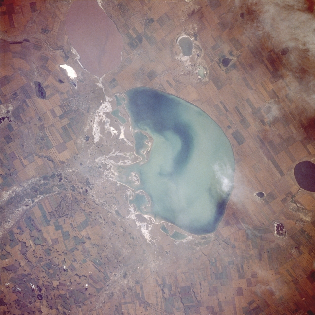
| STS028-076-084 Lake Kulundinskoye, Russia August 1989 Lake Kulundinskoye is located on the southern edge of the much larger West Siberian Plain of south-central Russia. This lake, along with many other lakes in the region, exhibits a wide array of colors. The variations in color suggest that each lake is at a different stage of eutrophication. The lake immediately south of Lake Kulundinskoye is mauve-colored, contrasting with the oval, dark blue lake along the northwest edge of the photograph. Two deltas can be observed along the eastern side of Lake Kulundinskoye. The white areas are probably salty minerals that were deposited on the surface as water evaporated. A well-established shelter belt system (a series of three parallel lines adjoining end to end) runs generally north-south along the eastern side of Lake Kulundinskoye to form a manmade barrier to help protect against wind erosion. The cultivated field patterns are large and basically rectangular in shape. (Refer to STS-068-225-010 for the overall physical setting of Lake Kulundinskoye and its proximity to the Russian-Kazakhstan border.) |
| Images: | All Available Images Low-Resolution 320k |
|
| Mission: | STS028 |
|
| Roll - Frame: | 76 - 84 |
|
| Geographical Name: | RUSSIAN FEDERATION |
|
| Features: | LAKE KULUNDINSKOYE |
|
| Center Lat x Lon: | 53.0N x 79.5E |
|
| Film Exposure: | N | N=Normal exposure, U=Under exposed, O=Over exposed, F=out of Focus |
| Percentage of Cloud Cover-CLDP: | 5 |
|
| Camera:: | HB |
|
| Camera Tilt: | NV | LO=Low Oblique, HO=High Oblique, NV=Near Vertical |
| Camera Focal Length: | 250 |
|
| Nadir to Photo Center Direction: | E | The direction from the nadir to the center point, N=North, S=South, E=East, W=West |
| Stereo?: | Y | Y=Yes there is an adjacent picture of the same area, N=No there isn't |
| Orbit Number: | 14 |
|
| Date: | 19890809 | YYYYMMDD |
| Time: | 083725 | GMT HHMMSS |
| Nadir Lat: | 52.6N |
Latitude of suborbital point of spacecraft |
| Nadir Lon: | 77.9E |
Longitude of suborbital point of spacecraft |
| Sun Azimuth: | 219 | Clockwise angle in degrees from north to the sun measured at the nadir point |
| Space Craft Altitude: | 162 | nautical miles |
| Sun Elevation: | 48 | Angle in degrees between the horizon and the sun, measured at the nadir point |
| Land Views: | PLAIN |
|
| Water Views: | LAKE, RIVER, DELTA |
|
| Atmosphere Views: | |
|
| Man Made Views: | AGRICULTURE, DAM |
|
| City Views: | |
|
Photo is not associated with any sequences | ||
| NASA Home Page |
JSC Home Page |
JSC Digital Image Collection |
Earth Science & Remote Sensing |
|
|